You are here: Home > Network List > UW - Pacific Northwest Regional Seismic Network Stations List
> Station YACT Amboy, WA, USA > Earthquake Result Viewer
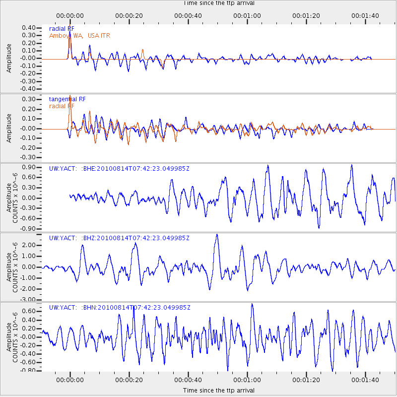
YACT Amboy, WA, USA - Earthquake Result Viewer
*The percent match for this event was below the threshold and hence no stack was calculated.
| Earthquake location: |
South Of Mariana Islands |
| Earthquake latitude/longitude: |
12.3/141.5 |
| Earthquake time(UTC): |
2010/08/14 (226) 07:30:16 GMT |
| Earthquake Depth: |
10 km |
| Earthquake Magnitude: |
6.0 MB, 6.0 MS, 6.2 MW, 6.1 MW |
| Earthquake Catalog/Contributor: |
WHDF/NEIC |
|
| Network: |
UW Pacific Northwest Regional Seismic Network |
| Station: |
YACT Amboy, WA, USA |
| Lat/Lon: |
45.93 N/122.42 W |
| Elevation: |
211 m |
|
| Distance: |
85.4 deg |
| Az: |
44.122 deg |
| Baz: |
282.903 deg |
| Ray Param: |
$rayparam |
*The percent match for this event was below the threshold and hence was not used in the summary stack. |
|
| Radial Match: |
76.61426 % |
| Radial Bump: |
400 |
| Transverse Match: |
64.89146 % |
| Transverse Bump: |
400 |
| SOD ConfigId: |
319893 |
| Insert Time: |
2011-01-05 22:03:15.387 +0000 |
| GWidth: |
2.5 |
| Max Bumps: |
400 |
| Tol: |
0.001 |
|
Signal To Noise
| Channel | StoN | STA | LTA |
| UW:YACT: :BHZ:20100814T07:42:23.049985Z | 6.212266 | 9.924366E-7 | 1.5975438E-7 |
| UW:YACT: :BHN:20100814T07:42:23.049985Z | 1.5309651 | 1.8807219E-7 | 1.228455E-7 |
| UW:YACT: :BHE:20100814T07:42:23.049985Z | 2.6349099 | 2.7607896E-7 | 1.0477739E-7 |
| Arrivals |
| Ps | |
| PpPs | |
| PsPs/PpSs | |


