You are here: Home > Network List > UW - Pacific Northwest Regional Seismic Network Stations List
> Station LEBA Lebam, WA, USA > Earthquake Result Viewer
LEBA Lebam, WA, USA - Earthquake Result Viewer
| Earthquake location: |
South Of Mariana Islands |
| Earthquake latitude/longitude: |
12.3/141.5 |
| Earthquake time(UTC): |
2010/08/14 (226) 07:30:16 GMT |
| Earthquake Depth: |
10 km |
| Earthquake Magnitude: |
6.0 MB, 6.0 MS, 6.2 MW, 6.1 MW |
| Earthquake Catalog/Contributor: |
WHDF/NEIC |
|
| Network: |
UW Pacific Northwest Regional Seismic Network |
| Station: |
LEBA Lebam, WA, USA |
| Lat/Lon: |
46.55 N/123.56 W |
| Elevation: |
73 m |
|
| Distance: |
84.5 deg |
| Az: |
43.693 deg |
| Baz: |
282.042 deg |
| Ray Param: |
0.04542687 |
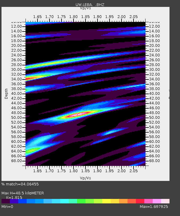
| Estimated Moho Depth: |
48.5 km |
| Estimated Crust Vp/Vs: |
1.82 |
| Assumed Crust Vp: |
6.566 km/s |
| Estimated Crust Vs: |
3.618 km/s |
| Estimated Crust Poisson's Ratio: |
0.28 |
|
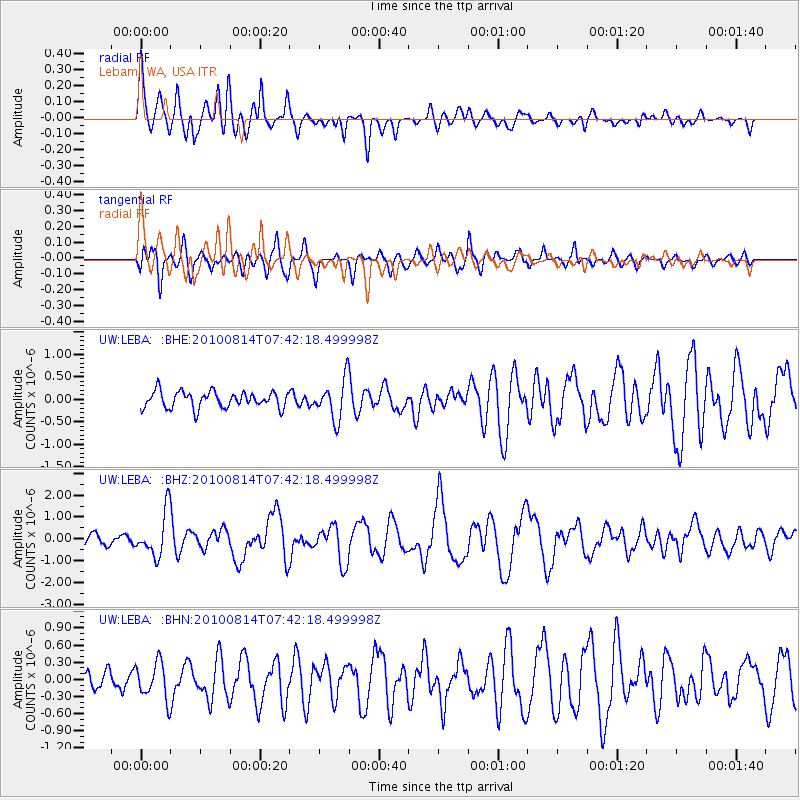
| Radial Match: |
84.06455 % |
| Radial Bump: |
400 |
| Transverse Match: |
84.52845 % |
| Transverse Bump: |
400 |
| SOD ConfigId: |
319893 |
| Insert Time: |
2011-01-05 22:04:25.050 +0000 |
| GWidth: |
2.5 |
| Max Bumps: |
400 |
| Tol: |
0.001 |
|
Signal To Noise
| Channel | StoN | STA | LTA |
| UW:LEBA: :BHZ:20100814T07:42:18.499998Z | 5.42801 | 1.009222E-6 | 1.8592854E-7 |
| UW:LEBA: :BHN:20100814T07:42:18.499998Z | 1.504193 | 3.214725E-7 | 2.1371758E-7 |
| UW:LEBA: :BHE:20100814T07:42:18.499998Z | 2.435719 | 4.432084E-7 | 1.8196204E-7 |
| Arrivals |
| Ps | 6.2 SECOND |
| PpPs | 20 SECOND |
| PsPs/PpSs | 26 SECOND |


