You are here: Home > Network List > UW - Pacific Northwest Regional Seismic Network Stations List
> Station PASS Maple Falls, WA, USA > Earthquake Result Viewer
PASS Maple Falls, WA, USA - Earthquake Result Viewer
| Earthquake location: |
South Of Mariana Islands |
| Earthquake latitude/longitude: |
12.3/141.5 |
| Earthquake time(UTC): |
2010/08/14 (226) 07:30:16 GMT |
| Earthquake Depth: |
10 km |
| Earthquake Magnitude: |
6.0 MB, 6.0 MS, 6.2 MW, 6.1 MW |
| Earthquake Catalog/Contributor: |
WHDF/NEIC |
|
| Network: |
UW Pacific Northwest Regional Seismic Network |
| Station: |
PASS Maple Falls, WA, USA |
| Lat/Lon: |
49.00 N/122.09 W |
| Elevation: |
174 m |
|
| Distance: |
85.0 deg |
| Az: |
41.071 deg |
| Baz: |
282.892 deg |
| Ray Param: |
0.045107715 |
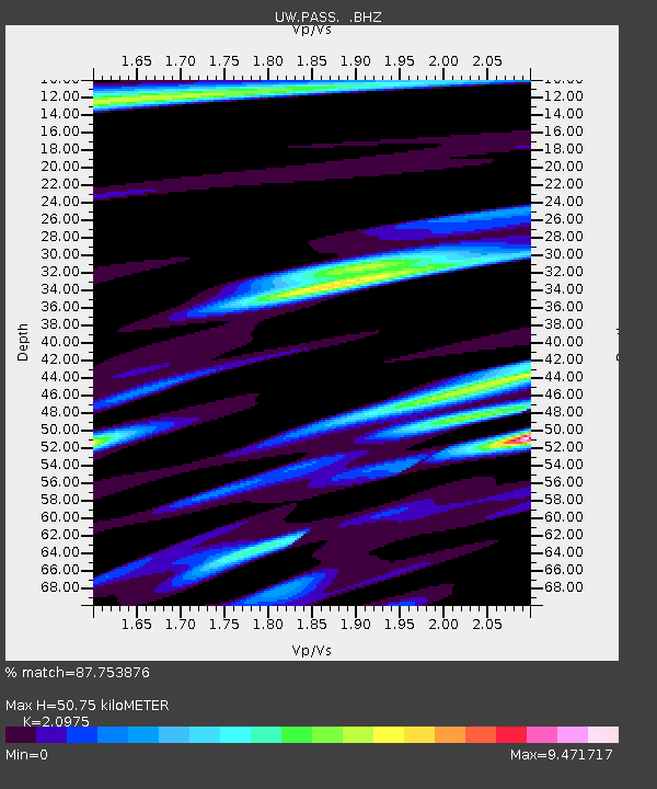
| Estimated Moho Depth: |
50.75 km |
| Estimated Crust Vp/Vs: |
2.10 |
| Assumed Crust Vp: |
6.566 km/s |
| Estimated Crust Vs: |
3.13 km/s |
| Estimated Crust Poisson's Ratio: |
0.35 |
|
| Radial Match: |
87.753876 % |
| Radial Bump: |
400 |
| Transverse Match: |
82.50342 % |
| Transverse Bump: |
400 |
| SOD ConfigId: |
319893 |
| Insert Time: |
2011-01-05 22:04:41.993 +0000 |
| GWidth: |
2.5 |
| Max Bumps: |
400 |
| Tol: |
0.001 |
|
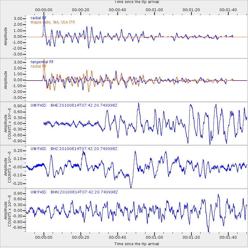
Signal To Noise
| Channel | StoN | STA | LTA |
| UW:PASS: :BHZ:20100814T07:42:20.749998Z | 2.129133 | 7.057355E-8 | 3.3146613E-8 |
| UW:PASS: :BHN:20100814T07:42:20.749998Z | 2.122921 | 1.9836256E-7 | 9.343851E-8 |
| UW:PASS: :BHE:20100814T07:42:20.749998Z | 4.677998 | 3.3214334E-7 | 7.1001175E-8 |
| Arrivals |
| Ps | 8.7 SECOND |
| PpPs | 23 SECOND |
| PsPs/PpSs | 32 SECOND |


