You are here: Home > Network List > CI - Caltech Regional Seismic Network Stations List
> Station VES Vestal, Richgrove, CA, USA > Earthquake Result Viewer
VES Vestal, Richgrove, CA, USA - Earthquake Result Viewer
| Earthquake location: |
South Of Mariana Islands |
| Earthquake latitude/longitude: |
12.4/141.6 |
| Earthquake time(UTC): |
2010/08/14 (226) 07:31:01 GMT |
| Earthquake Depth: |
10 km |
| Earthquake Magnitude: |
5.7 MB |
| Earthquake Catalog/Contributor: |
WHDF/NEIC |
|
| Network: |
CI Caltech Regional Seismic Network |
| Station: |
VES Vestal, Richgrove, CA, USA |
| Lat/Lon: |
35.84 N/119.08 W |
| Elevation: |
154 m |
|
| Distance: |
90.2 deg |
| Az: |
53.31 deg |
| Baz: |
285.389 deg |
| Ray Param: |
0.041690227 |
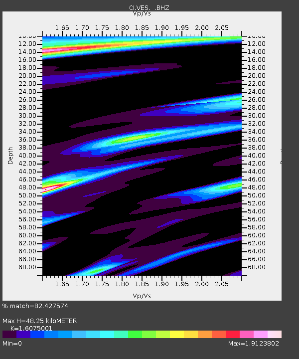
| Estimated Moho Depth: |
48.25 km |
| Estimated Crust Vp/Vs: |
1.61 |
| Assumed Crust Vp: |
6.1 km/s |
| Estimated Crust Vs: |
3.795 km/s |
| Estimated Crust Poisson's Ratio: |
0.18 |
|
| Radial Match: |
82.427574 % |
| Radial Bump: |
355 |
| Transverse Match: |
60.28046 % |
| Transverse Bump: |
317 |
| SOD ConfigId: |
319893 |
| Insert Time: |
2011-01-05 22:21:37.982 +0000 |
| GWidth: |
2.5 |
| Max Bumps: |
400 |
| Tol: |
0.001 |
|

Signal To Noise
| Channel | StoN | STA | LTA |
| CI:VES: :BHZ:20100814T07:43:30.880999Z | 1.549374 | 7.072516E-7 | 4.5647573E-7 |
| CI:VES: :BHN:20100814T07:43:30.880022Z | 2.6994853 | 7.998993E-7 | 2.9631548E-7 |
| CI:VES: :BHE:20100814T07:43:30.880022Z | 1.1640209 | 5.976938E-7 | 5.134734E-7 |
| Arrivals |
| Ps | 4.9 SECOND |
| PpPs | 20 SECOND |
| PsPs/PpSs | 25 SECOND |


