You are here: Home > Network List > UW - Pacific Northwest Regional Seismic Network Stations List
> Station IRON Crane, OR, USA > Earthquake Result Viewer
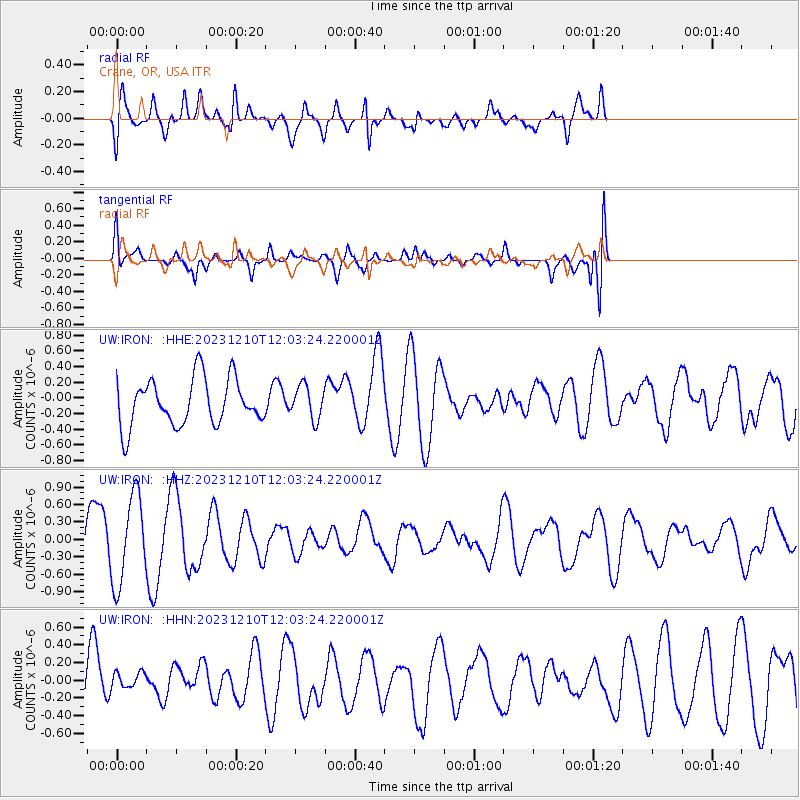
IRON Crane, OR, USA - Earthquake Result Viewer
*The percent match for this event was below the threshold and hence no stack was calculated.
| Earthquake location: |
Near Coast Of Peru |
| Earthquake latitude/longitude: |
-14.4/-76.5 |
| Earthquake time(UTC): |
2023/12/10 (344) 11:52:49 GMT |
| Earthquake Depth: |
10 km |
| Earthquake Magnitude: |
5.7 Mww |
| Earthquake Catalog/Contributor: |
NEIC PDE/us |
|
| Network: |
UW Pacific Northwest Regional Seismic Network |
| Station: |
IRON Crane, OR, USA |
| Lat/Lon: |
43.36 N/118.47 W |
| Elevation: |
1226 m |
|
| Distance: |
69.1 deg |
| Az: |
328.497 deg |
| Baz: |
136.026 deg |
| Ray Param: |
$rayparam |
*The percent match for this event was below the threshold and hence was not used in the summary stack. |
|
| Radial Match: |
57.81946 % |
| Radial Bump: |
400 |
| Transverse Match: |
46.60337 % |
| Transverse Bump: |
400 |
| SOD ConfigId: |
33232451 |
| Insert Time: |
2023-12-24 12:15:55.203 +0000 |
| GWidth: |
2.5 |
| Max Bumps: |
400 |
| Tol: |
0.001 |
|
Signal To Noise
| Channel | StoN | STA | LTA |
| UW:IRON: :HHZ:20231210T12:03:24.220001Z | 2.1311622 | 7.5716144E-7 | 3.55281E-7 |
| UW:IRON: :HHN:20231210T12:03:24.220001Z | 0.2854726 | 1.0035503E-7 | 3.5153997E-7 |
| UW:IRON: :HHE:20231210T12:03:24.220001Z | 0.7075764 | 2.1183533E-7 | 2.9938155E-7 |
| Arrivals |
| Ps | |
| PpPs | |
| PsPs/PpSs | |


