You are here: Home > Network List > MY - Malaysian National Seismic Network Stations List
> Station KUM Kulim > Earthquake Result Viewer
KUM Kulim - Earthquake Result Viewer
| Earthquake location: |
South Of Mariana Islands |
| Earthquake latitude/longitude: |
12.4/141.6 |
| Earthquake time(UTC): |
2010/08/14 (226) 07:31:01 GMT |
| Earthquake Depth: |
10 km |
| Earthquake Magnitude: |
5.7 MB |
| Earthquake Catalog/Contributor: |
WHDF/NEIC |
|
| Network: |
MY Malaysian National Seismic Network |
| Station: |
KUM Kulim |
| Lat/Lon: |
5.29 N/100.65 E |
| Elevation: |
74 m |
|
| Distance: |
41.1 deg |
| Az: |
263.79 deg |
| Baz: |
77.238 deg |
| Ray Param: |
0.074023224 |
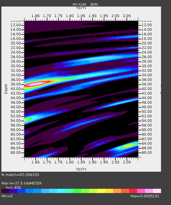
| Estimated Moho Depth: |
37.5 km |
| Estimated Crust Vp/Vs: |
1.65 |
| Assumed Crust Vp: |
6.468 km/s |
| Estimated Crust Vs: |
3.908 km/s |
| Estimated Crust Poisson's Ratio: |
0.21 |
|
| Radial Match: |
92.056335 % |
| Radial Bump: |
349 |
| Transverse Match: |
81.53324 % |
| Transverse Bump: |
400 |
| SOD ConfigId: |
319893 |
| Insert Time: |
2011-01-05 22:24:27.713 +0000 |
| GWidth: |
2.5 |
| Max Bumps: |
400 |
| Tol: |
0.001 |
|

Signal To Noise
| Channel | StoN | STA | LTA |
| MY:KUM: :BHZ:20100814T07:38:14.719988Z | 1.4515879 | 1.4310853E-6 | 9.858758E-7 |
| MY:KUM: :BHN:20100814T07:38:14.719988Z | 2.2658236 | 5.3537724E-7 | 2.3628374E-7 |
| MY:KUM: :BHE:20100814T07:38:14.719988Z | 2.021724 | 9.4650716E-7 | 4.6816837E-7 |
| Arrivals |
| Ps | 4.1 SECOND |
| PpPs | 14 SECOND |
| PsPs/PpSs | 18 SECOND |


