You are here: Home > Network List > TA - USArray Transportable Network (new EarthScope stations) Stations List
> Station H20A Greybull, WY, USA > Earthquake Result Viewer
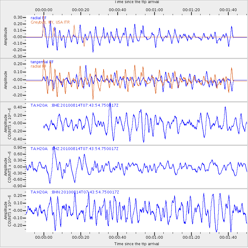
H20A Greybull, WY, USA - Earthquake Result Viewer
*The percent match for this event was below the threshold and hence no stack was calculated.
| Earthquake location: |
South Of Mariana Islands |
| Earthquake latitude/longitude: |
12.4/141.6 |
| Earthquake time(UTC): |
2010/08/14 (226) 07:31:01 GMT |
| Earthquake Depth: |
10 km |
| Earthquake Magnitude: |
5.7 MB |
| Earthquake Catalog/Contributor: |
WHDF/NEIC |
|
| Network: |
TA USArray Transportable Network (new EarthScope stations) |
| Station: |
H20A Greybull, WY, USA |
| Lat/Lon: |
44.49 N/108.00 W |
| Elevation: |
1236 m |
|
| Distance: |
95.4 deg |
| Az: |
42.377 deg |
| Baz: |
293.082 deg |
| Ray Param: |
$rayparam |
*The percent match for this event was below the threshold and hence was not used in the summary stack. |
|
| Radial Match: |
64.29716 % |
| Radial Bump: |
400 |
| Transverse Match: |
70.76146 % |
| Transverse Bump: |
400 |
| SOD ConfigId: |
319893 |
| Insert Time: |
2011-01-05 22:25:14.980 +0000 |
| GWidth: |
2.5 |
| Max Bumps: |
400 |
| Tol: |
0.001 |
|
Signal To Noise
| Channel | StoN | STA | LTA |
| TA:H20A: :BHZ:20100814T07:43:54.750017Z | 1.4179685 | 3.2370326E-7 | 2.2828664E-7 |
| TA:H20A: :BHN:20100814T07:43:54.750017Z | 1.067398 | 7.996647E-8 | 7.491721E-8 |
| TA:H20A: :BHE:20100814T07:43:54.750017Z | 1.2056756 | 1.1701821E-7 | 9.705614E-8 |
| Arrivals |
| Ps | |
| PpPs | |
| PsPs/PpSs | |


