You are here: Home > Network List > TA - USArray Transportable Network (new EarthScope stations) Stations List
> Station D27A Center, ND, USA > Earthquake Result Viewer
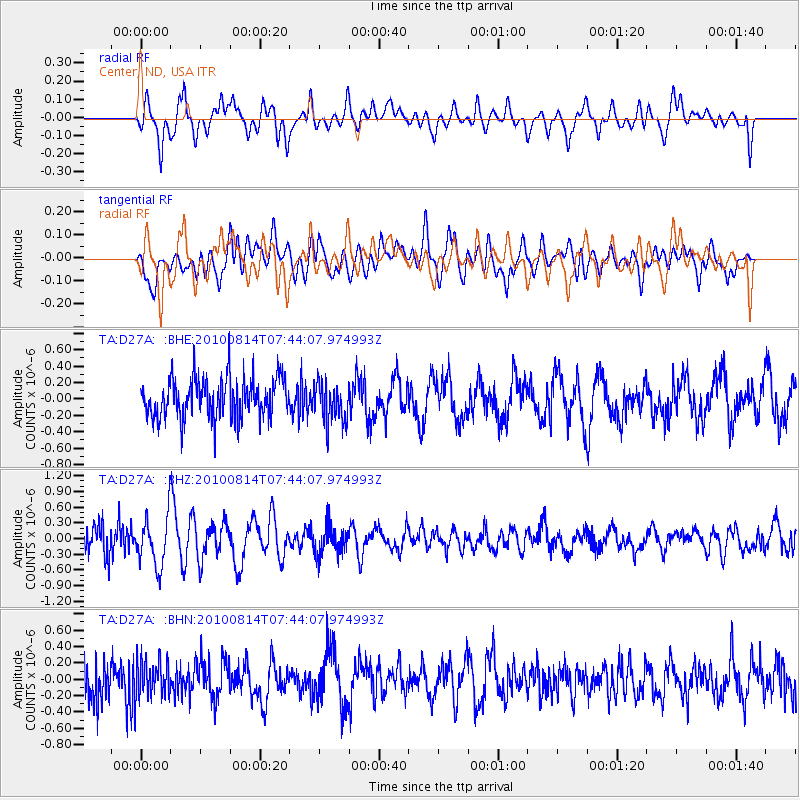
D27A Center, ND, USA - Earthquake Result Viewer
*The percent match for this event was below the threshold and hence no stack was calculated.
| Earthquake location: |
South Of Mariana Islands |
| Earthquake latitude/longitude: |
12.4/141.6 |
| Earthquake time(UTC): |
2010/08/14 (226) 07:31:01 GMT |
| Earthquake Depth: |
10 km |
| Earthquake Magnitude: |
5.7 MB |
| Earthquake Catalog/Contributor: |
WHDF/NEIC |
|
| Network: |
TA USArray Transportable Network (new EarthScope stations) |
| Station: |
D27A Center, ND, USA |
| Lat/Lon: |
47.11 N/101.53 W |
| Elevation: |
685 m |
|
| Distance: |
98.4 deg |
| Az: |
38.026 deg |
| Baz: |
298.233 deg |
| Ray Param: |
$rayparam |
*The percent match for this event was below the threshold and hence was not used in the summary stack. |
|
| Radial Match: |
75.260254 % |
| Radial Bump: |
400 |
| Transverse Match: |
65.38146 % |
| Transverse Bump: |
400 |
| SOD ConfigId: |
319893 |
| Insert Time: |
2011-01-05 22:26:05.711 +0000 |
| GWidth: |
2.5 |
| Max Bumps: |
400 |
| Tol: |
0.001 |
|
Signal To Noise
| Channel | StoN | STA | LTA |
| TA:D27A: :BHZ:20100814T07:44:07.974993Z | 1.8447865 | 4.610947E-7 | 2.4994472E-7 |
| TA:D27A: :BHN:20100814T07:44:07.974993Z | 0.9615246 | 2.3280327E-7 | 2.421189E-7 |
| TA:D27A: :BHE:20100814T07:44:07.974993Z | 0.98676145 | 2.3609394E-7 | 2.392614E-7 |
| Arrivals |
| Ps | |
| PpPs | |
| PsPs/PpSs | |


