You are here: Home > Network List > MM - Myanmar National Seismic Network Stations List
> Station NGU Ngaung U, Myanmar > Earthquake Result Viewer
NGU Ngaung U, Myanmar - Earthquake Result Viewer
| Earthquake location: |
Mariana Islands |
| Earthquake latitude/longitude: |
18.8/146.1 |
| Earthquake time(UTC): |
2023/12/10 (344) 14:11:39 GMT |
| Earthquake Depth: |
119 km |
| Earthquake Magnitude: |
5.7 mww |
| Earthquake Catalog/Contributor: |
NEIC PDE/us |
|
| Network: |
MM Myanmar National Seismic Network |
| Station: |
NGU Ngaung U, Myanmar |
| Lat/Lon: |
21.21 N/94.92 E |
| Elevation: |
70 m |
|
| Distance: |
48.0 deg |
| Az: |
281.922 deg |
| Baz: |
83.432 deg |
| Ray Param: |
0.0692536 |
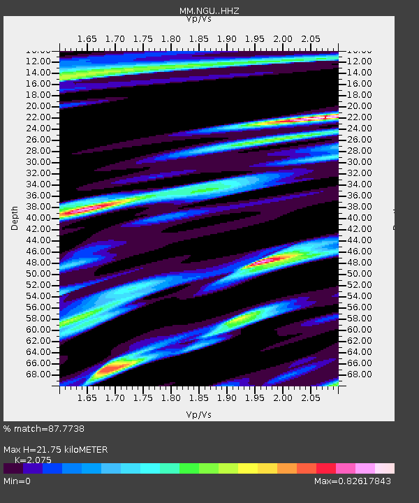
| Estimated Moho Depth: |
21.75 km |
| Estimated Crust Vp/Vs: |
2.08 |
| Assumed Crust Vp: |
6.036 km/s |
| Estimated Crust Vs: |
2.909 km/s |
| Estimated Crust Poisson's Ratio: |
0.35 |
|
| Radial Match: |
87.7738 % |
| Radial Bump: |
400 |
| Transverse Match: |
70.16734 % |
| Transverse Bump: |
400 |
| SOD ConfigId: |
33232451 |
| Insert Time: |
2023-12-24 14:26:53.830 +0000 |
| GWidth: |
2.5 |
| Max Bumps: |
400 |
| Tol: |
0.001 |
|

Signal To Noise
| Channel | StoN | STA | LTA |
| MM:NGU: :HHZ:20231210T14:19:36.060009Z | 6.951174 | 6.5326014E-7 | 9.397839E-8 |
| MM:NGU: :HHN:20231210T14:19:36.060009Z | 1.0921762 | 2.0801207E-7 | 1.9045652E-7 |
| MM:NGU: :HHE:20231210T14:19:36.060009Z | 0.8552455 | 1.4757751E-7 | 1.7255573E-7 |
| Arrivals |
| Ps | 4.1 SECOND |
| PpPs | 11 SECOND |
| PsPs/PpSs | 15 SECOND |


