You are here: Home > Network List > UU - University of Utah Regional Network Stations List
> Station FORU South Mineral Mountains, UT, USA > Earthquake Result Viewer
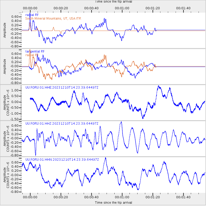
FORU South Mineral Mountains, UT, USA - Earthquake Result Viewer
*The percent match for this event was below the threshold and hence no stack was calculated.
| Earthquake location: |
Mariana Islands |
| Earthquake latitude/longitude: |
18.8/146.1 |
| Earthquake time(UTC): |
2023/12/10 (344) 14:11:39 GMT |
| Earthquake Depth: |
119 km |
| Earthquake Magnitude: |
5.7 mww |
| Earthquake Catalog/Contributor: |
NEIC PDE/us |
|
| Network: |
UU University of Utah Regional Network |
| Station: |
FORU South Mineral Mountains, UT, USA |
| Lat/Lon: |
38.46 N/112.86 W |
| Elevation: |
1840 m |
|
| Distance: |
86.8 deg |
| Az: |
50.508 deg |
| Baz: |
291.365 deg |
| Ray Param: |
$rayparam |
*The percent match for this event was below the threshold and hence was not used in the summary stack. |
|
| Radial Match: |
37.506535 % |
| Radial Bump: |
373 |
| Transverse Match: |
72.54854 % |
| Transverse Bump: |
400 |
| SOD ConfigId: |
33232451 |
| Insert Time: |
2023-12-24 14:32:40.782 +0000 |
| GWidth: |
2.5 |
| Max Bumps: |
400 |
| Tol: |
0.001 |
|
Signal To Noise
| Channel | StoN | STA | LTA |
| UU:FORU:01:HHZ:20231210T14:23:39.64497Z | 2.9194283 | 2.83288E-7 | 9.7035425E-8 |
| UU:FORU:01:HHN:20231210T14:23:39.64497Z | 2.2688446 | 5.324663E-7 | 2.346861E-7 |
| UU:FORU:01:HHE:20231210T14:23:39.64497Z | 1.7003486 | 5.4681095E-7 | 3.2158755E-7 |
| Arrivals |
| Ps | |
| PpPs | |
| PsPs/PpSs | |


