You are here: Home > Network List > TA - USArray Transportable Network (new EarthScope stations) Stations List
> Station I20A Worland, WY, USA > Earthquake Result Viewer
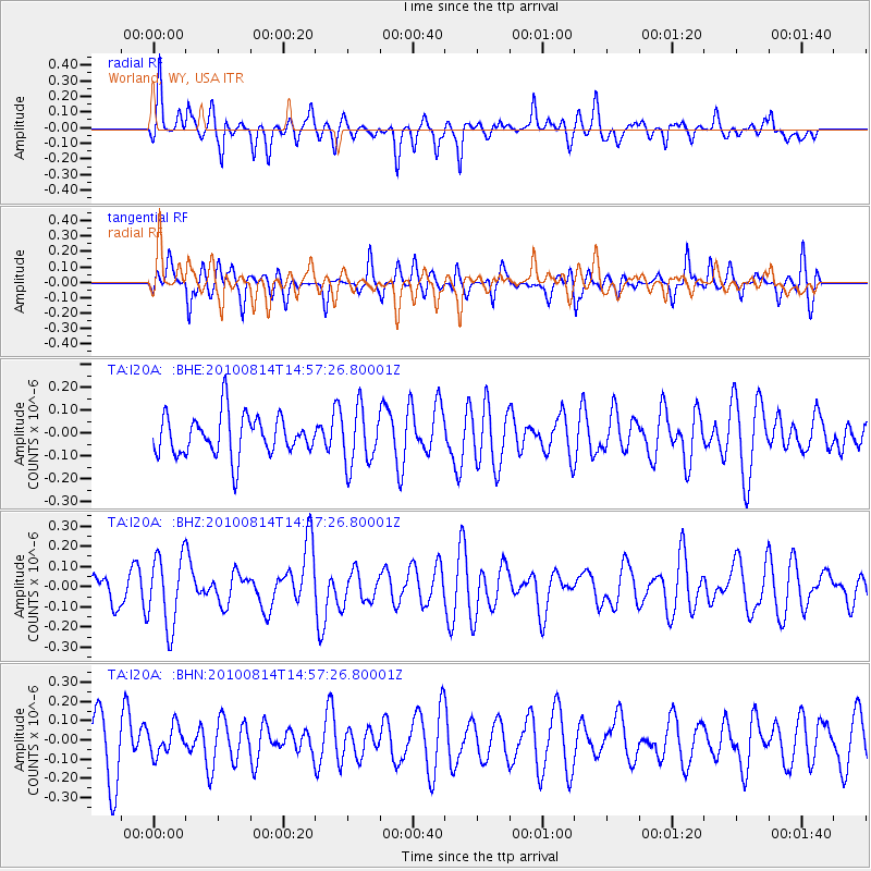
I20A Worland, WY, USA - Earthquake Result Viewer
*The percent match for this event was below the threshold and hence no stack was calculated.
| Earthquake location: |
South Of Mariana Islands |
| Earthquake latitude/longitude: |
12.3/141.5 |
| Earthquake time(UTC): |
2010/08/14 (226) 14:44:32 GMT |
| Earthquake Depth: |
10 km |
| Earthquake Magnitude: |
5.6 MB, 5.6 MW, 5.6 ME |
| Earthquake Catalog/Contributor: |
WHDF/NEIC |
|
| Network: |
TA USArray Transportable Network (new EarthScope stations) |
| Station: |
I20A Worland, WY, USA |
| Lat/Lon: |
43.95 N/108.13 W |
| Elevation: |
1342 m |
|
| Distance: |
95.7 deg |
| Az: |
42.869 deg |
| Baz: |
292.994 deg |
| Ray Param: |
$rayparam |
*The percent match for this event was below the threshold and hence was not used in the summary stack. |
|
| Radial Match: |
55.10702 % |
| Radial Bump: |
400 |
| Transverse Match: |
44.180557 % |
| Transverse Bump: |
363 |
| SOD ConfigId: |
319893 |
| Insert Time: |
2011-01-05 22:35:45.364 +0000 |
| GWidth: |
2.5 |
| Max Bumps: |
400 |
| Tol: |
0.001 |
|
Signal To Noise
| Channel | StoN | STA | LTA |
| TA:I20A: :BHZ:20100814T14:57:26.80001Z | 2.3702447 | 1.7494098E-7 | 7.3807136E-8 |
| TA:I20A: :BHN:20100814T14:57:26.80001Z | 0.56123894 | 7.324032E-8 | 1.3049758E-7 |
| TA:I20A: :BHE:20100814T14:57:26.80001Z | 1.4029676 | 1.2358176E-7 | 8.808597E-8 |
| Arrivals |
| Ps | |
| PpPs | |
| PsPs/PpSs | |


