You are here: Home > Network List > TA - USArray Transportable Network (new EarthScope stations) Stations List
> Station G05D Wamic, OR, USA > Earthquake Result Viewer
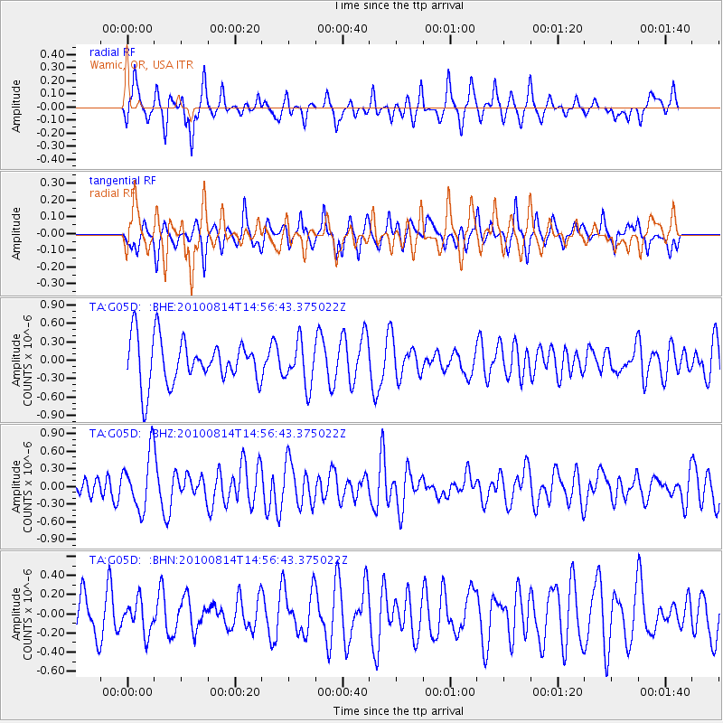
G05D Wamic, OR, USA - Earthquake Result Viewer
*The percent match for this event was below the threshold and hence no stack was calculated.
| Earthquake location: |
South Of Mariana Islands |
| Earthquake latitude/longitude: |
12.3/141.5 |
| Earthquake time(UTC): |
2010/08/14 (226) 14:44:32 GMT |
| Earthquake Depth: |
10 km |
| Earthquake Magnitude: |
5.6 MB, 5.6 MW, 5.6 ME |
| Earthquake Catalog/Contributor: |
WHDF/NEIC |
|
| Network: |
TA USArray Transportable Network (new EarthScope stations) |
| Station: |
G05D Wamic, OR, USA |
| Lat/Lon: |
45.24 N/121.32 W |
| Elevation: |
592 m |
|
| Distance: |
86.4 deg |
| Az: |
44.611 deg |
| Baz: |
283.713 deg |
| Ray Param: |
$rayparam |
*The percent match for this event was below the threshold and hence was not used in the summary stack. |
|
| Radial Match: |
61.587585 % |
| Radial Bump: |
376 |
| Transverse Match: |
47.87274 % |
| Transverse Bump: |
343 |
| SOD ConfigId: |
319893 |
| Insert Time: |
2011-01-05 22:36:19.418 +0000 |
| GWidth: |
2.5 |
| Max Bumps: |
400 |
| Tol: |
0.001 |
|
Signal To Noise
| Channel | StoN | STA | LTA |
| TA:G05D: :BHZ:20100814T14:56:43.375022Z | 2.2676492 | 4.704649E-7 | 2.074681E-7 |
| TA:G05D: :BHN:20100814T14:56:43.375022Z | 0.6905258 | 1.6764392E-7 | 2.427772E-7 |
| TA:G05D: :BHE:20100814T14:56:43.375022Z | 0.96880513 | 3.5462696E-7 | 3.6604573E-7 |
| Arrivals |
| Ps | |
| PpPs | |
| PsPs/PpSs | |


