You are here: Home > Network List > IU - Global Seismograph Network (GSN - IRIS/USGS) Stations List
> Station HNR Honiara, Solomon Islands > Earthquake Result Viewer
HNR Honiara, Solomon Islands - Earthquake Result Viewer
| Earthquake location: |
South Of Kermadec Islands |
| Earthquake latitude/longitude: |
-32.0/-177.9 |
| Earthquake time(UTC): |
2019/03/06 (065) 15:46:14 GMT |
| Earthquake Depth: |
29 km |
| Earthquake Magnitude: |
6.4 Mww |
| Earthquake Catalog/Contributor: |
NEIC PDE/us |
|
| Network: |
IU Global Seismograph Network (GSN - IRIS/USGS) |
| Station: |
HNR Honiara, Solomon Islands |
| Lat/Lon: |
9.44 S/159.95 E |
| Elevation: |
100 m |
|
| Distance: |
30.5 deg |
| Az: |
312.716 deg |
| Baz: |
140.763 deg |
| Ray Param: |
0.07930325 |
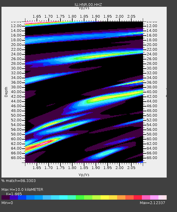
| Estimated Moho Depth: |
10.0 km |
| Estimated Crust Vp/Vs: |
1.66 |
| Assumed Crust Vp: |
6.183 km/s |
| Estimated Crust Vs: |
3.713 km/s |
| Estimated Crust Poisson's Ratio: |
0.22 |
|
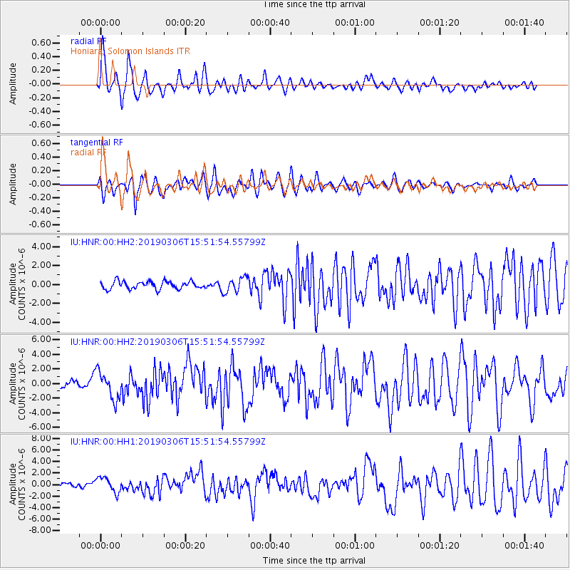
| Radial Match: |
86.3303 % |
| Radial Bump: |
400 |
| Transverse Match: |
64.89419 % |
| Transverse Bump: |
400 |
| SOD ConfigId: |
3338192 |
| Insert Time: |
2019-03-20 15:50:03.928 +0000 |
| GWidth: |
2.5 |
| Max Bumps: |
400 |
| Tol: |
0.001 |
|
Signal To Noise
| Channel | StoN | STA | LTA |
| IU:HNR:00:HHZ:20190306T15:51:54.55799Z | 6.631803 | 1.8833972E-6 | 2.8399475E-7 |
| IU:HNR:00:HH1:20190306T15:51:54.55799Z | 3.8850718 | 1.3238431E-6 | 3.4075126E-7 |
| IU:HNR:00:HH2:20190306T15:51:54.55799Z | 1.916054 | 7.79349E-7 | 4.067469E-7 |
| Arrivals |
| Ps | 1.2 SECOND |
| PpPs | 4.0 SECOND |
| PsPs/PpSs | 5.1 SECOND |


