You are here: Home > Network List > CI - Caltech Regional Seismic Network Stations List
> Station MPM Manuel Prospect Mine, California, USA > Earthquake Result Viewer
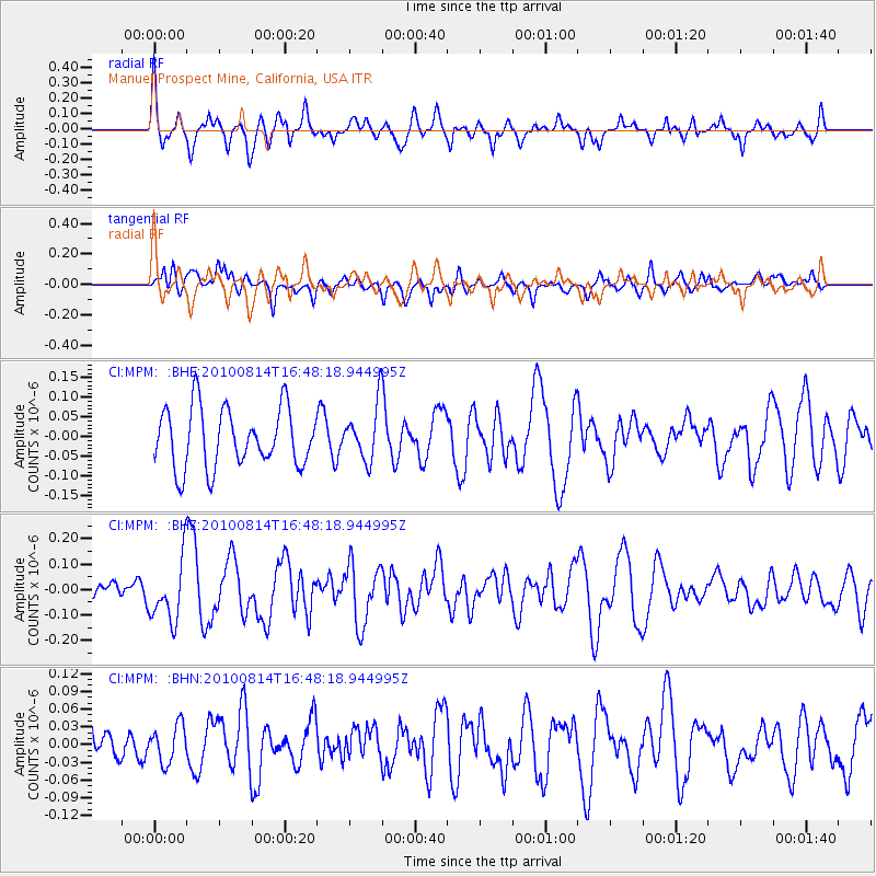
MPM Manuel Prospect Mine, California, USA - Earthquake Result Viewer
*The percent match for this event was below the threshold and hence no stack was calculated.
| Earthquake location: |
South Of Mariana Islands |
| Earthquake latitude/longitude: |
12.3/141.6 |
| Earthquake time(UTC): |
2010/08/14 (226) 16:35:43 GMT |
| Earthquake Depth: |
10 km |
| Earthquake Magnitude: |
5.7 MW, 5.4 MB |
| Earthquake Catalog/Contributor: |
WHDF/NEIC |
|
| Network: |
CI Caltech Regional Seismic Network |
| Station: |
MPM Manuel Prospect Mine, California, USA |
| Lat/Lon: |
36.06 N/117.49 W |
| Elevation: |
185 m |
|
| Distance: |
91.5 deg |
| Az: |
52.734 deg |
| Baz: |
286.284 deg |
| Ray Param: |
$rayparam |
*The percent match for this event was below the threshold and hence was not used in the summary stack. |
|
| Radial Match: |
62.137924 % |
| Radial Bump: |
383 |
| Transverse Match: |
54.13776 % |
| Transverse Bump: |
400 |
| SOD ConfigId: |
319893 |
| Insert Time: |
2011-01-05 22:41:32.317 +0000 |
| GWidth: |
2.5 |
| Max Bumps: |
400 |
| Tol: |
0.001 |
|
Signal To Noise
| Channel | StoN | STA | LTA |
| CI:MPM: :BHZ:20100814T16:48:18.944995Z | 2.4908977 | 1.2077192E-7 | 4.84853E-8 |
| CI:MPM: :BHN:20100814T16:48:18.944995Z | 0.6077228 | 3.1262168E-8 | 5.1441486E-8 |
| CI:MPM: :BHE:20100814T16:48:18.944995Z | 0.9356913 | 6.98149E-8 | 7.4613176E-8 |
| Arrivals |
| Ps | |
| PpPs | |
| PsPs/PpSs | |


