You are here: Home > Network List > IU - Global Seismograph Network (GSN - IRIS/USGS) Stations List
> Station RSSD Black Hills, South Dakota, USA > Earthquake Result Viewer
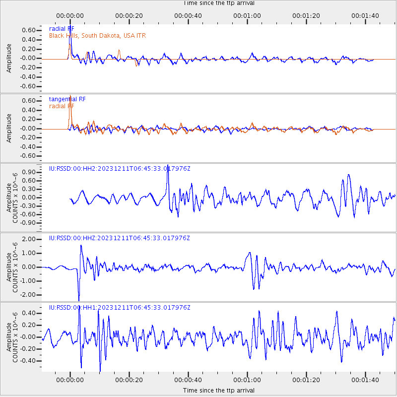
RSSD Black Hills, South Dakota, USA - Earthquake Result Viewer
*The percent match for this event was below the threshold and hence no stack was calculated.
| Earthquake location: |
Tonga Islands |
| Earthquake latitude/longitude: |
-18.7/-175.5 |
| Earthquake time(UTC): |
2023/12/11 (345) 06:33:31 GMT |
| Earthquake Depth: |
238 km |
| Earthquake Magnitude: |
6.1 Mww |
| Earthquake Catalog/Contributor: |
NEIC PDE/us |
|
| Network: |
IU Global Seismograph Network (GSN - IRIS/USGS) |
| Station: |
RSSD Black Hills, South Dakota, USA |
| Lat/Lon: |
44.12 N/104.04 W |
| Elevation: |
2090 m |
|
| Distance: |
90.2 deg |
| Az: |
43.061 deg |
| Baz: |
243.992 deg |
| Ray Param: |
$rayparam |
*The percent match for this event was below the threshold and hence was not used in the summary stack. |
|
| Radial Match: |
74.22627 % |
| Radial Bump: |
287 |
| Transverse Match: |
51.511814 % |
| Transverse Bump: |
340 |
| SOD ConfigId: |
33232451 |
| Insert Time: |
2023-12-25 06:55:06.993 +0000 |
| GWidth: |
2.5 |
| Max Bumps: |
400 |
| Tol: |
0.001 |
|
Signal To Noise
| Channel | StoN | STA | LTA |
| IU:RSSD:00:HHZ:20231211T06:45:33.017976Z | 7.4331627 | 8.247015E-7 | 1.1094893E-7 |
| IU:RSSD:00:HH1:20231211T06:45:33.017976Z | 2.3871365 | 1.9849178E-7 | 8.315058E-8 |
| IU:RSSD:00:HH2:20231211T06:45:33.017976Z | 3.381932 | 4.0164744E-7 | 1.1876272E-7 |
| Arrivals |
| Ps | |
| PpPs | |
| PsPs/PpSs | |


