You are here: Home > Network List > KN - Kyrgyz Seismic Telemetry Network Stations List
> Station CHM KN.CHM > Earthquake Result Viewer
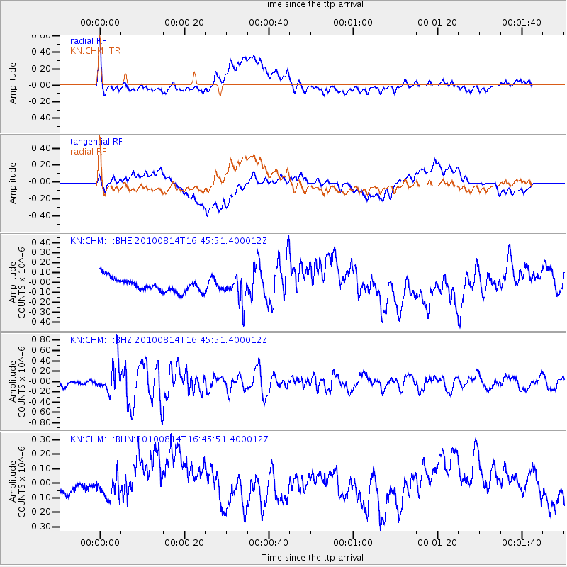
CHM KN.CHM - Earthquake Result Viewer
*The percent match for this event was below the threshold and hence no stack was calculated.
| Earthquake location: |
South Of Mariana Islands |
| Earthquake latitude/longitude: |
12.3/141.6 |
| Earthquake time(UTC): |
2010/08/14 (226) 16:35:43 GMT |
| Earthquake Depth: |
10 km |
| Earthquake Magnitude: |
5.7 MW, 5.4 MB |
| Earthquake Catalog/Contributor: |
WHDF/NEIC |
|
| Network: |
KN Kyrgyz Seismic Telemetry Network |
| Station: |
CHM KN.CHM |
| Lat/Lon: |
43.00 N/74.75 E |
| Elevation: |
655 m |
|
| Distance: |
64.8 deg |
| Az: |
311.799 deg |
| Baz: |
96.738 deg |
| Ray Param: |
$rayparam |
*The percent match for this event was below the threshold and hence was not used in the summary stack. |
|
| Radial Match: |
60.018093 % |
| Radial Bump: |
400 |
| Transverse Match: |
41.22754 % |
| Transverse Bump: |
400 |
| SOD ConfigId: |
319893 |
| Insert Time: |
2011-01-05 22:44:04.215 +0000 |
| GWidth: |
2.5 |
| Max Bumps: |
400 |
| Tol: |
0.001 |
|
Signal To Noise
| Channel | StoN | STA | LTA |
| KN:CHM: :BHZ:20100814T16:45:51.400012Z | 5.2030725 | 3.021105E-7 | 5.806386E-8 |
| KN:CHM: :BHN:20100814T16:45:51.400012Z | 1.9267855 | 9.8198484E-8 | 5.0964925E-8 |
| KN:CHM: :BHE:20100814T16:45:51.400012Z | 1.9561687 | 1.2973217E-7 | 6.631952E-8 |
| Arrivals |
| Ps | |
| PpPs | |
| PsPs/PpSs | |


