You are here: Home > Network List > TX - Texas Seismological Network Stations List
> Station MB10 Stanton > Earthquake Result Viewer
MB10 Stanton - Earthquake Result Viewer
| Earthquake location: |
Tonga Islands |
| Earthquake latitude/longitude: |
-18.7/-175.5 |
| Earthquake time(UTC): |
2023/12/11 (345) 06:33:31 GMT |
| Earthquake Depth: |
238 km |
| Earthquake Magnitude: |
6.1 Mww |
| Earthquake Catalog/Contributor: |
NEIC PDE/us |
|
| Network: |
TX Texas Seismological Network |
| Station: |
MB10 Stanton |
| Lat/Lon: |
32.27 N/101.79 W |
| Elevation: |
813 m |
|
| Distance: |
86.8 deg |
| Az: |
54.529 deg |
| Baz: |
245.685 deg |
| Ray Param: |
0.043246828 |
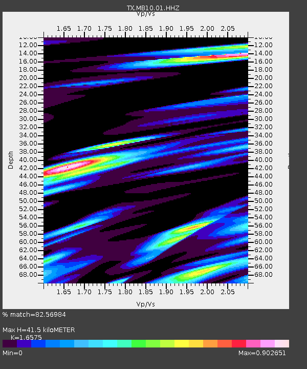
| Estimated Moho Depth: |
41.5 km |
| Estimated Crust Vp/Vs: |
1.66 |
| Assumed Crust Vp: |
6.426 km/s |
| Estimated Crust Vs: |
3.877 km/s |
| Estimated Crust Poisson's Ratio: |
0.21 |
|
| Radial Match: |
82.56984 % |
| Radial Bump: |
400 |
| Transverse Match: |
76.085396 % |
| Transverse Bump: |
400 |
| SOD ConfigId: |
33232451 |
| Insert Time: |
2023-12-25 07:04:53.398 +0000 |
| GWidth: |
2.5 |
| Max Bumps: |
400 |
| Tol: |
0.001 |
|

Signal To Noise
| Channel | StoN | STA | LTA |
| TX:MB10:01:HHZ:20231211T06:45:16.905Z | 6.2756205 | 1.0213683E-6 | 1.6275177E-7 |
| TX:MB10:01:HHN:20231211T06:45:16.905Z | 0.81633806 | 2.0578827E-7 | 2.5208706E-7 |
| TX:MB10:01:HHE:20231211T06:45:16.905Z | 1.0588171 | 2.5456066E-7 | 2.4041984E-7 |
| Arrivals |
| Ps | 4.3 SECOND |
| PpPs | 17 SECOND |
| PsPs/PpSs | 21 SECOND |


