You are here: Home > Network List > TX - Texas Seismological Network Stations List
> Station PB22 South of Coyonosa > Earthquake Result Viewer
PB22 South of Coyonosa - Earthquake Result Viewer
| Earthquake location: |
Tonga Islands |
| Earthquake latitude/longitude: |
-18.7/-175.5 |
| Earthquake time(UTC): |
2023/12/11 (345) 06:33:31 GMT |
| Earthquake Depth: |
238 km |
| Earthquake Magnitude: |
6.1 Mww |
| Earthquake Catalog/Contributor: |
NEIC PDE/us |
|
| Network: |
TX Texas Seismological Network |
| Station: |
PB22 South of Coyonosa |
| Lat/Lon: |
31.21 N/103.08 W |
| Elevation: |
808 m |
|
| Distance: |
85.3 deg |
| Az: |
55.028 deg |
| Baz: |
245.047 deg |
| Ray Param: |
0.044270173 |
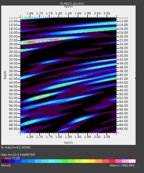
| Estimated Moho Depth: |
22.0 km |
| Estimated Crust Vp/Vs: |
1.71 |
| Assumed Crust Vp: |
6.121 km/s |
| Estimated Crust Vs: |
3.574 km/s |
| Estimated Crust Poisson's Ratio: |
0.24 |
|
| Radial Match: |
82.40561 % |
| Radial Bump: |
400 |
| Transverse Match: |
72.53578 % |
| Transverse Bump: |
400 |
| SOD ConfigId: |
33232451 |
| Insert Time: |
2023-12-25 07:05:21.796 +0000 |
| GWidth: |
2.5 |
| Max Bumps: |
400 |
| Tol: |
0.001 |
|

Signal To Noise
| Channel | StoN | STA | LTA |
| TX:PB22:00:HHZ:20231211T06:45:09.949982Z | 5.528255 | 1.794861E-7 | 3.2467042E-8 |
| TX:PB22:00:HH1:20231211T06:45:09.949982Z | 2.2655766 | 4.3592514E-8 | 1.9241243E-8 |
| TX:PB22:00:HH2:20231211T06:45:09.949982Z | 1.133687 | 2.527709E-8 | 2.2296357E-8 |
| Arrivals |
| Ps | 2.6 SECOND |
| PpPs | 9.5 SECOND |
| PsPs/PpSs | 12 SECOND |


