You are here: Home > Network List > TX - Texas Seismological Network Stations List
> Station SAND Sanderson > Earthquake Result Viewer
SAND Sanderson - Earthquake Result Viewer
| Earthquake location: |
Tonga Islands |
| Earthquake latitude/longitude: |
-18.7/-175.5 |
| Earthquake time(UTC): |
2023/12/11 (345) 06:33:31 GMT |
| Earthquake Depth: |
238 km |
| Earthquake Magnitude: |
6.1 Mww |
| Earthquake Catalog/Contributor: |
NEIC PDE/us |
|
| Network: |
TX Texas Seismological Network |
| Station: |
SAND Sanderson |
| Lat/Lon: |
29.95 N/102.12 W |
| Elevation: |
689 m |
|
| Distance: |
85.6 deg |
| Az: |
56.514 deg |
| Baz: |
245.648 deg |
| Ray Param: |
0.044110082 |
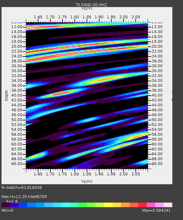
| Estimated Moho Depth: |
12.25 km |
| Estimated Crust Vp/Vs: |
1.60 |
| Assumed Crust Vp: |
6.419 km/s |
| Estimated Crust Vs: |
4.012 km/s |
| Estimated Crust Poisson's Ratio: |
0.18 |
|
| Radial Match: |
82.816536 % |
| Radial Bump: |
400 |
| Transverse Match: |
80.321625 % |
| Transverse Bump: |
400 |
| SOD ConfigId: |
33232451 |
| Insert Time: |
2023-12-25 07:05:37.343 +0000 |
| GWidth: |
2.5 |
| Max Bumps: |
400 |
| Tol: |
0.001 |
|

Signal To Noise
| Channel | StoN | STA | LTA |
| TX:SAND:00:HHZ:20231211T06:45:11.050019Z | 3.2039902 | 4.1469602E-7 | 1.2943111E-7 |
| TX:SAND:00:HH1:20231211T06:45:11.050019Z | 1.713597 | 1.6399946E-7 | 9.570479E-8 |
| TX:SAND:00:HH2:20231211T06:45:11.050019Z | 1.4589678 | 1.5293173E-7 | 1.0482187E-7 |
| Arrivals |
| Ps | 1.2 SECOND |
| PpPs | 4.8 SECOND |
| PsPs/PpSs | 6.0 SECOND |


