You are here: Home > Network List > US - United States National Seismic Network Stations List
> Station BOZ Bozeman, Montana, USA > Earthquake Result Viewer
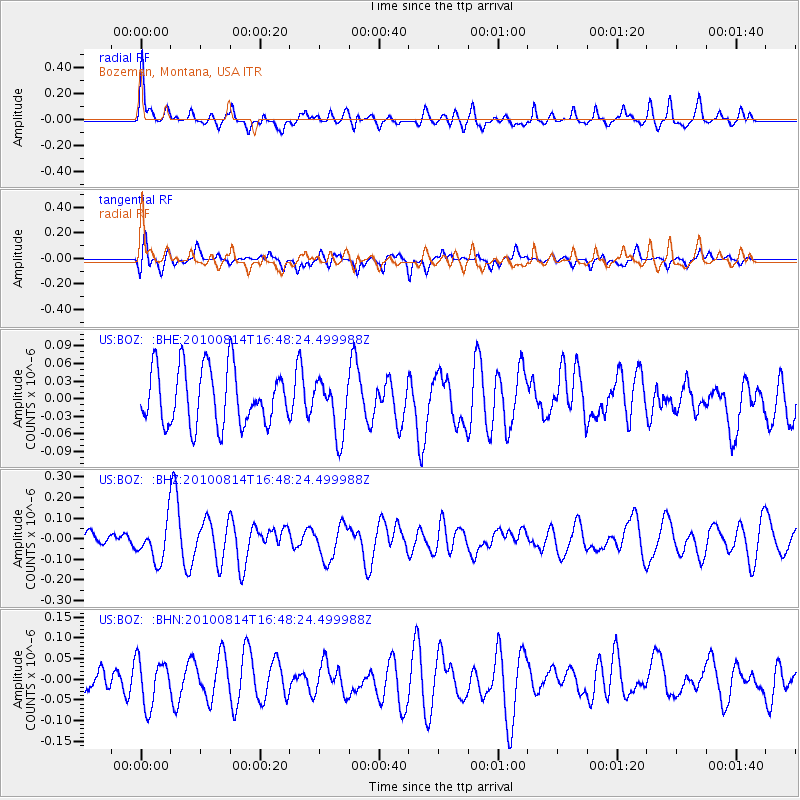
BOZ Bozeman, Montana, USA - Earthquake Result Viewer
*The percent match for this event was below the threshold and hence no stack was calculated.
| Earthquake location: |
South Of Mariana Islands |
| Earthquake latitude/longitude: |
12.3/141.6 |
| Earthquake time(UTC): |
2010/08/14 (226) 16:35:43 GMT |
| Earthquake Depth: |
10 km |
| Earthquake Magnitude: |
5.7 MW, 5.4 MB |
| Earthquake Catalog/Contributor: |
WHDF/NEIC |
|
| Network: |
US United States National Seismic Network |
| Station: |
BOZ Bozeman, Montana, USA |
| Lat/Lon: |
45.65 N/111.63 W |
| Elevation: |
1589 m |
|
| Distance: |
92.7 deg |
| Az: |
42.243 deg |
| Baz: |
290.504 deg |
| Ray Param: |
$rayparam |
*The percent match for this event was below the threshold and hence was not used in the summary stack. |
|
| Radial Match: |
70.83534 % |
| Radial Bump: |
400 |
| Transverse Match: |
48.36386 % |
| Transverse Bump: |
400 |
| SOD ConfigId: |
319893 |
| Insert Time: |
2011-01-05 22:47:46.699 +0000 |
| GWidth: |
2.5 |
| Max Bumps: |
400 |
| Tol: |
0.001 |
|
Signal To Noise
| Channel | StoN | STA | LTA |
| US:BOZ: :BHZ:20100814T16:48:24.499988Z | 2.478912 | 9.313037E-8 | 3.756905E-8 |
| US:BOZ: :BHN:20100814T16:48:24.499988Z | 1.7297428 | 5.631596E-8 | 3.255742E-8 |
| US:BOZ: :BHE:20100814T16:48:24.499988Z | 0.97615135 | 4.733486E-8 | 4.8491316E-8 |
| Arrivals |
| Ps | |
| PpPs | |
| PsPs/PpSs | |


