You are here: Home > Network List > TX - Texas Seismological Network Stations List
> Station PB34 Salt Mine 2 > Earthquake Result Viewer
PB34 Salt Mine 2 - Earthquake Result Viewer
| Earthquake location: |
Tonga Islands |
| Earthquake latitude/longitude: |
-18.7/-175.5 |
| Earthquake time(UTC): |
2023/12/11 (345) 06:33:31 GMT |
| Earthquake Depth: |
238 km |
| Earthquake Magnitude: |
6.1 Mww |
| Earthquake Catalog/Contributor: |
NEIC PDE/us |
|
| Network: |
TX Texas Seismological Network |
| Station: |
PB34 Salt Mine 2 |
| Lat/Lon: |
31.68 N/104.04 W |
| Elevation: |
969 m |
|
| Distance: |
84.8 deg |
| Az: |
54.256 deg |
| Baz: |
244.482 deg |
| Ray Param: |
0.044649787 |
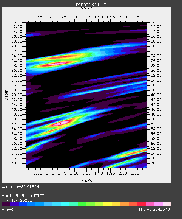
| Estimated Moho Depth: |
51.5 km |
| Estimated Crust Vp/Vs: |
1.74 |
| Assumed Crust Vp: |
6.361 km/s |
| Estimated Crust Vs: |
3.65 km/s |
| Estimated Crust Poisson's Ratio: |
0.25 |
|
| Radial Match: |
80.61854 % |
| Radial Bump: |
400 |
| Transverse Match: |
52.8109 % |
| Transverse Bump: |
371 |
| SOD ConfigId: |
33232451 |
| Insert Time: |
2023-12-25 07:06:15.339 +0000 |
| GWidth: |
2.5 |
| Max Bumps: |
400 |
| Tol: |
0.001 |
|

Signal To Noise
| Channel | StoN | STA | LTA |
| TX:PB34:00:HHZ:20231211T06:45:07.25998Z | 3.2082682 | 8.538471E-7 | 2.6613958E-7 |
| TX:PB34:00:HH1:20231211T06:45:07.25998Z | 1.1187028 | 1.1718357E-7 | 1.0474952E-7 |
| TX:PB34:00:HH2:20231211T06:45:07.25998Z | 1.0375487 | 1.5785575E-7 | 1.5214299E-7 |
| Arrivals |
| Ps | 6.2 SECOND |
| PpPs | 22 SECOND |
| PsPs/PpSs | 28 SECOND |


