You are here: Home > Network List > TX - Texas Seismological Network Stations List
> Station PB38 UTL Block 46 > Earthquake Result Viewer
PB38 UTL Block 46 - Earthquake Result Viewer
| Earthquake location: |
Tonga Islands |
| Earthquake latitude/longitude: |
-18.7/-175.5 |
| Earthquake time(UTC): |
2023/12/11 (345) 06:33:31 GMT |
| Earthquake Depth: |
238 km |
| Earthquake Magnitude: |
6.1 Mww |
| Earthquake Catalog/Contributor: |
NEIC PDE/us |
|
| Network: |
TX Texas Seismological Network |
| Station: |
PB38 UTL Block 46 |
| Lat/Lon: |
31.73 N/104.43 W |
| Elevation: |
1240 m |
|
| Distance: |
84.5 deg |
| Az: |
54.064 deg |
| Baz: |
244.26 deg |
| Ray Param: |
0.044843838 |
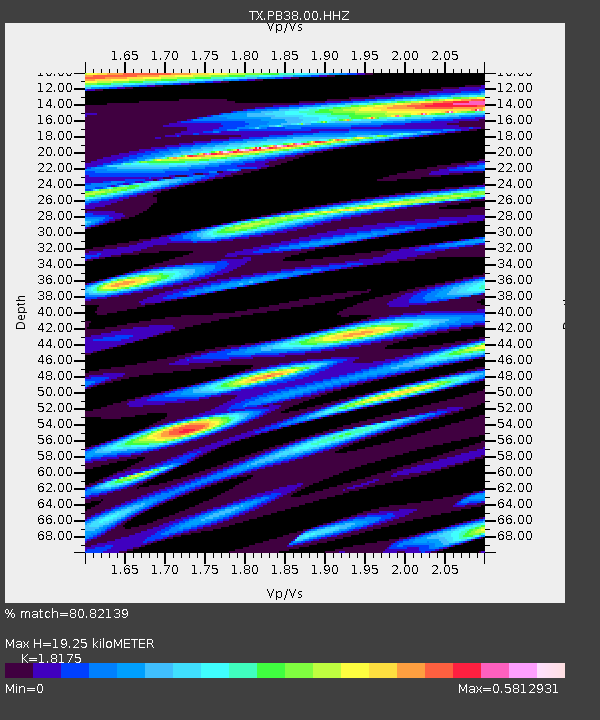
| Estimated Moho Depth: |
19.25 km |
| Estimated Crust Vp/Vs: |
1.82 |
| Assumed Crust Vp: |
6.361 km/s |
| Estimated Crust Vs: |
3.5 km/s |
| Estimated Crust Poisson's Ratio: |
0.28 |
|
| Radial Match: |
80.82139 % |
| Radial Bump: |
400 |
| Transverse Match: |
59.650475 % |
| Transverse Bump: |
400 |
| SOD ConfigId: |
33232451 |
| Insert Time: |
2023-12-25 07:06:19.266 +0000 |
| GWidth: |
2.5 |
| Max Bumps: |
400 |
| Tol: |
0.001 |
|

Signal To Noise
| Channel | StoN | STA | LTA |
| TX:PB38:00:HHZ:20231211T06:45:05.889985Z | 4.57411 | 9.53948E-7 | 2.0855379E-7 |
| TX:PB38:00:HH1:20231211T06:45:05.889985Z | 2.1119425 | 2.3512318E-7 | 1.11330294E-7 |
| TX:PB38:00:HH2:20231211T06:45:05.889985Z | 2.2207034 | 2.5817175E-7 | 1.1625676E-7 |
| Arrivals |
| Ps | 2.5 SECOND |
| PpPs | 8.3 SECOND |
| PsPs/PpSs | 11 SECOND |


