You are here: Home > Network List > US - United States National Seismic Network Stations List
> Station MIAR Mount Ida, Arkansas, USA > Earthquake Result Viewer
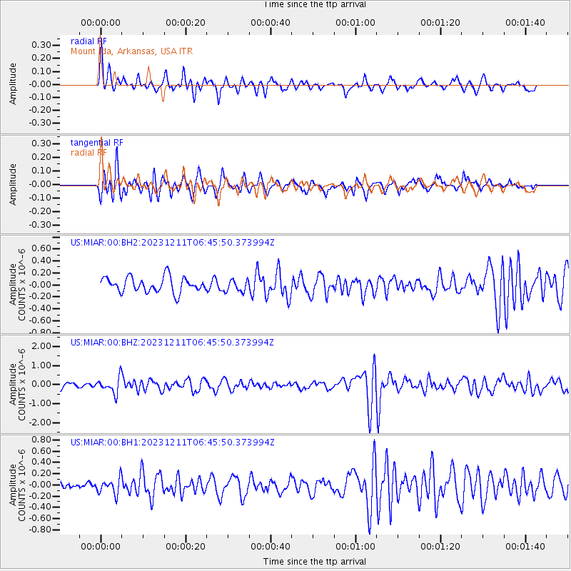
MIAR Mount Ida, Arkansas, USA - Earthquake Result Viewer
*The percent match for this event was below the threshold and hence no stack was calculated.
| Earthquake location: |
Tonga Islands |
| Earthquake latitude/longitude: |
-18.7/-175.5 |
| Earthquake time(UTC): |
2023/12/11 (345) 06:33:31 GMT |
| Earthquake Depth: |
238 km |
| Earthquake Magnitude: |
6.1 Mww |
| Earthquake Catalog/Contributor: |
NEIC PDE/us |
|
| Network: |
US United States National Seismic Network |
| Station: |
MIAR Mount Ida, Arkansas, USA |
| Lat/Lon: |
34.55 N/93.58 W |
| Elevation: |
207 m |
|
| Distance: |
94.0 deg |
| Az: |
55.006 deg |
| Baz: |
250.19 deg |
| Ray Param: |
$rayparam |
*The percent match for this event was below the threshold and hence was not used in the summary stack. |
|
| Radial Match: |
65.43271 % |
| Radial Bump: |
386 |
| Transverse Match: |
61.24784 % |
| Transverse Bump: |
400 |
| SOD ConfigId: |
33232451 |
| Insert Time: |
2023-12-25 07:08:54.476 +0000 |
| GWidth: |
2.5 |
| Max Bumps: |
400 |
| Tol: |
0.001 |
|
Signal To Noise
| Channel | StoN | STA | LTA |
| US:MIAR:00:BHZ:20231211T06:45:50.373994Z | 1.7094983 | 4.2165044E-7 | 2.4665158E-7 |
| US:MIAR:00:BH1:20231211T06:45:50.373994Z | 1.5147101 | 1.4185485E-7 | 9.3651494E-8 |
| US:MIAR:00:BH2:20231211T06:45:50.373994Z | 0.7739271 | 9.7854894E-8 | 1.2643942E-7 |
| Arrivals |
| Ps | |
| PpPs | |
| PsPs/PpSs | |


