You are here: Home > Network List > UU - University of Utah Regional Network Stations List
> Station FOR6 FORGE > Earthquake Result Viewer
FOR6 FORGE - Earthquake Result Viewer
| Earthquake location: |
Tonga Islands |
| Earthquake latitude/longitude: |
-18.7/-175.5 |
| Earthquake time(UTC): |
2023/12/11 (345) 06:33:31 GMT |
| Earthquake Depth: |
238 km |
| Earthquake Magnitude: |
6.1 Mww |
| Earthquake Catalog/Contributor: |
NEIC PDE/us |
|
| Network: |
UU University of Utah Regional Network |
| Station: |
FOR6 FORGE |
| Lat/Lon: |
38.49 N/112.79 W |
| Elevation: |
2421 m |
|
| Distance: |
81.7 deg |
| Az: |
44.802 deg |
| Baz: |
238.346 deg |
| Ray Param: |
0.046791174 |
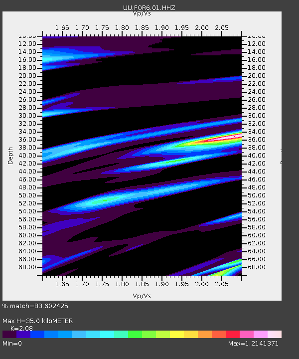
| Estimated Moho Depth: |
35.0 km |
| Estimated Crust Vp/Vs: |
2.08 |
| Assumed Crust Vp: |
6.276 km/s |
| Estimated Crust Vs: |
3.017 km/s |
| Estimated Crust Poisson's Ratio: |
0.35 |
|
| Radial Match: |
83.602425 % |
| Radial Bump: |
400 |
| Transverse Match: |
83.32117 % |
| Transverse Bump: |
400 |
| SOD ConfigId: |
33232451 |
| Insert Time: |
2023-12-25 07:09:33.494 +0000 |
| GWidth: |
2.5 |
| Max Bumps: |
400 |
| Tol: |
0.001 |
|

Signal To Noise
| Channel | StoN | STA | LTA |
| UU:FOR6:01:HHZ:20231211T06:44:51.709992Z | 9.626753 | 9.320025E-7 | 9.681379E-8 |
| UU:FOR6:01:HHN:20231211T06:44:51.709992Z | 1.2811235 | 1.5063229E-7 | 1.17578274E-7 |
| UU:FOR6:01:HHE:20231211T06:44:51.709992Z | 1.9510378 | 2.935221E-7 | 1.504441E-7 |
| Arrivals |
| Ps | 6.2 SECOND |
| PpPs | 17 SECOND |
| PsPs/PpSs | 23 SECOND |


