You are here: Home > Network List > WY - Yellowstone Wyoming Seismic Network Stations List
> Station YHB Horse Butte YNP, MT, USA > Earthquake Result Viewer
YHB Horse Butte YNP, MT, USA - Earthquake Result Viewer
| Earthquake location: |
Tonga Islands |
| Earthquake latitude/longitude: |
-18.7/-175.5 |
| Earthquake time(UTC): |
2023/12/11 (345) 06:33:31 GMT |
| Earthquake Depth: |
238 km |
| Earthquake Magnitude: |
6.1 Mww |
| Earthquake Catalog/Contributor: |
NEIC PDE/us |
|
| Network: |
WY Yellowstone Wyoming Seismic Network |
| Station: |
YHB Horse Butte YNP, MT, USA |
| Lat/Lon: |
44.75 N/111.20 W |
| Elevation: |
2167 m |
|
| Distance: |
86.0 deg |
| Az: |
40.057 deg |
| Baz: |
238.893 deg |
| Ray Param: |
0.04379331 |
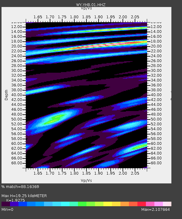
| Estimated Moho Depth: |
19.25 km |
| Estimated Crust Vp/Vs: |
1.93 |
| Assumed Crust Vp: |
6.35 km/s |
| Estimated Crust Vs: |
3.294 km/s |
| Estimated Crust Poisson's Ratio: |
0.32 |
|
| Radial Match: |
88.16369 % |
| Radial Bump: |
393 |
| Transverse Match: |
91.38487 % |
| Transverse Bump: |
325 |
| SOD ConfigId: |
33232451 |
| Insert Time: |
2023-12-25 07:14:26.696 +0000 |
| GWidth: |
2.5 |
| Max Bumps: |
400 |
| Tol: |
0.001 |
|

Signal To Noise
| Channel | StoN | STA | LTA |
| WY:YHB:01:HHZ:20231211T06:45:13.220002Z | 7.128727 | 1.138082E-6 | 1.596473E-7 |
| WY:YHB:01:HHN:20231211T06:45:13.220002Z | 2.3212519 | 3.2662953E-7 | 1.4071267E-7 |
| WY:YHB:01:HHE:20231211T06:45:13.220002Z | 2.1091437 | 4.1727407E-7 | 1.9784049E-7 |
| Arrivals |
| Ps | 2.9 SECOND |
| PpPs | 8.7 SECOND |
| PsPs/PpSs | 12 SECOND |


