You are here: Home > Network List > IW - Intermountain West Stations List
> Station MOOW Moose Ponds, Wyoming, USA > Earthquake Result Viewer
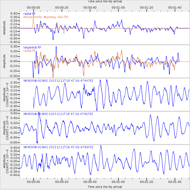
MOOW Moose Ponds, Wyoming, USA - Earthquake Result Viewer
*The percent match for this event was below the threshold and hence no stack was calculated.
| Earthquake location: |
Salta Province, Argentina |
| Earthquake latitude/longitude: |
-24.1/-66.8 |
| Earthquake time(UTC): |
2023/12/11 (345) 18:36:00 GMT |
| Earthquake Depth: |
195 km |
| Earthquake Magnitude: |
5.5 Mww |
| Earthquake Catalog/Contributor: |
NEIC PDE/us |
|
| Network: |
IW Intermountain West |
| Station: |
MOOW Moose Ponds, Wyoming, USA |
| Lat/Lon: |
43.75 N/110.74 W |
| Elevation: |
2128 m |
|
| Distance: |
78.6 deg |
| Az: |
329.161 deg |
| Baz: |
139.732 deg |
| Ray Param: |
$rayparam |
*The percent match for this event was below the threshold and hence was not used in the summary stack. |
|
| Radial Match: |
38.666 % |
| Radial Bump: |
400 |
| Transverse Match: |
50.506615 % |
| Transverse Bump: |
400 |
| SOD ConfigId: |
33232451 |
| Insert Time: |
2023-12-25 18:46:12.133 +0000 |
| GWidth: |
2.5 |
| Max Bumps: |
400 |
| Tol: |
0.001 |
|
Signal To Noise
| Channel | StoN | STA | LTA |
| IW:MOOW:00:BHZ:20231211T18:47:09.474976Z | 2.2800593 | 3.4818203E-7 | 1.5270744E-7 |
| IW:MOOW:00:BH1:20231211T18:47:09.474976Z | 0.90896934 | 1.5988283E-7 | 1.7589463E-7 |
| IW:MOOW:00:BH2:20231211T18:47:09.474976Z | 0.8771658 | 1.3955795E-7 | 1.5910099E-7 |
| Arrivals |
| Ps | |
| PpPs | |
| PsPs/PpSs | |


