You are here: Home > Network List > CI - Caltech Regional Seismic Network Stations List
> Station SWS Sam W. Stewart, Westmorland, CA, USA > Earthquake Result Viewer
SWS Sam W. Stewart, Westmorland, CA, USA - Earthquake Result Viewer
| Earthquake location: |
South Of Mariana Islands |
| Earthquake latitude/longitude: |
12.3/141.4 |
| Earthquake time(UTC): |
2010/08/14 (226) 23:01:04 GMT |
| Earthquake Depth: |
13 km |
| Earthquake Magnitude: |
6.1 MB, 6.3 MS, 6.6 MW, 6.3 MW |
| Earthquake Catalog/Contributor: |
WHDF/NEIC |
|
| Network: |
CI Caltech Regional Seismic Network |
| Station: |
SWS Sam W. Stewart, Westmorland, CA, USA |
| Lat/Lon: |
32.94 N/115.80 W |
| Elevation: |
140 m |
|
| Distance: |
93.9 deg |
| Az: |
55.28 deg |
| Baz: |
287.173 deg |
| Ray Param: |
0.04117368 |
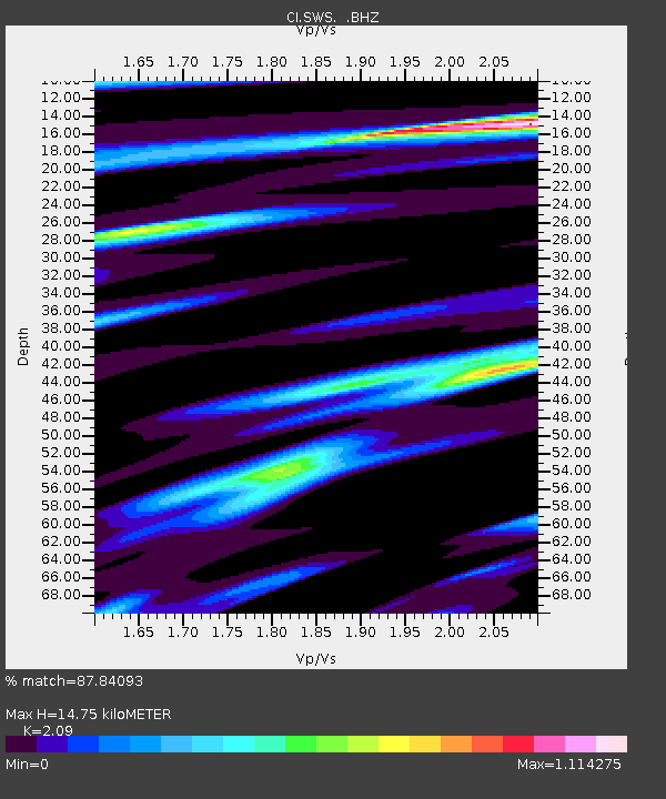
| Estimated Moho Depth: |
14.75 km |
| Estimated Crust Vp/Vs: |
2.09 |
| Assumed Crust Vp: |
6.155 km/s |
| Estimated Crust Vs: |
2.945 km/s |
| Estimated Crust Poisson's Ratio: |
0.35 |
|
| Radial Match: |
87.84093 % |
| Radial Bump: |
400 |
| Transverse Match: |
81.571625 % |
| Transverse Bump: |
400 |
| SOD ConfigId: |
319893 |
| Insert Time: |
2011-01-05 22:57:12.293 +0000 |
| GWidth: |
2.5 |
| Max Bumps: |
400 |
| Tol: |
0.001 |
|

Signal To Noise
| Channel | StoN | STA | LTA |
| CI:SWS: :BHZ:20100814T23:13:49.394993Z | 5.569919 | 4.596745E-7 | 8.252805E-8 |
| CI:SWS: :BHN:20100814T23:13:49.394993Z | 1.0224123 | 1.0931033E-7 | 1.06914136E-7 |
| CI:SWS: :BHE:20100814T23:13:49.394993Z | 2.1551075 | 2.3568276E-7 | 1.093601E-7 |
| Arrivals |
| Ps | 2.7 SECOND |
| PpPs | 7.3 SECOND |
| PsPs/PpSs | 9.9 SECOND |


