You are here: Home > Network List > CI - Caltech Regional Seismic Network Stations List
> Station MPP McPhearson Peak > Earthquake Result Viewer
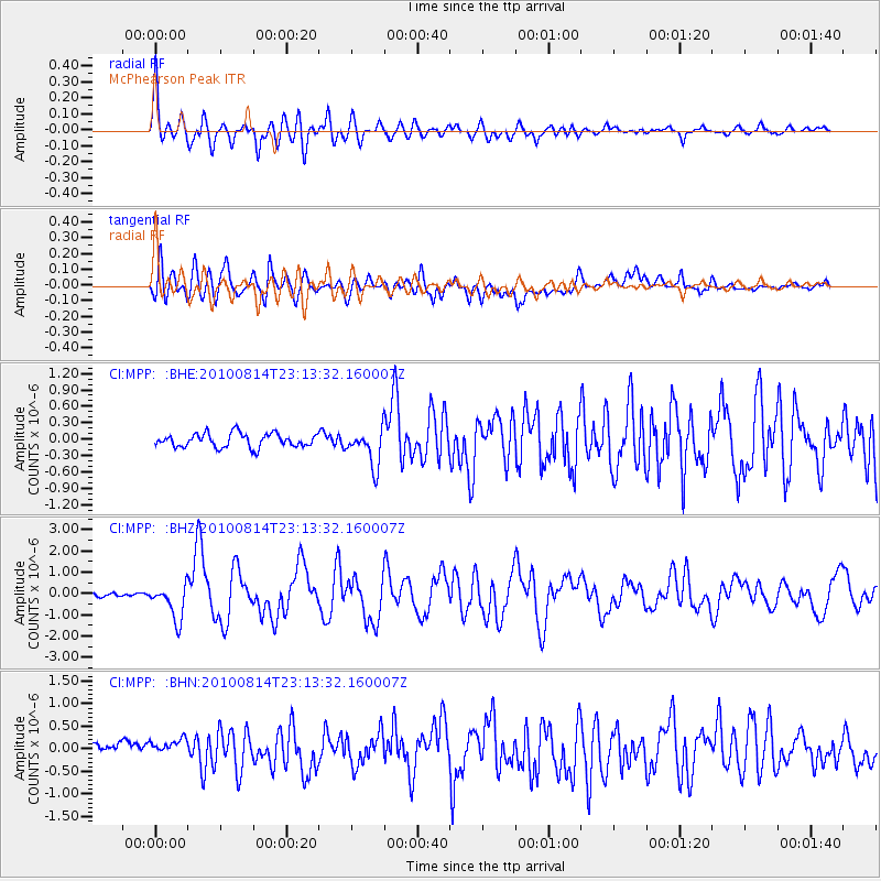
MPP McPhearson Peak - Earthquake Result Viewer
*The percent match for this event was below the threshold and hence no stack was calculated.
| Earthquake location: |
South Of Mariana Islands |
| Earthquake latitude/longitude: |
12.3/141.4 |
| Earthquake time(UTC): |
2010/08/14 (226) 23:01:04 GMT |
| Earthquake Depth: |
13 km |
| Earthquake Magnitude: |
6.1 MB, 6.3 MS, 6.6 MW, 6.3 MW |
| Earthquake Catalog/Contributor: |
WHDF/NEIC |
|
| Network: |
CI Caltech Regional Seismic Network |
| Station: |
MPP McPhearson Peak |
| Lat/Lon: |
34.89 N/119.81 W |
| Elevation: |
1739 m |
|
| Distance: |
90.1 deg |
| Az: |
54.339 deg |
| Baz: |
284.973 deg |
| Ray Param: |
$rayparam |
*The percent match for this event was below the threshold and hence was not used in the summary stack. |
|
| Radial Match: |
86.2181 % |
| Radial Bump: |
400 |
| Transverse Match: |
78.48113 % |
| Transverse Bump: |
400 |
| SOD ConfigId: |
319893 |
| Insert Time: |
2011-01-05 22:57:56.037 +0000 |
| GWidth: |
2.5 |
| Max Bumps: |
400 |
| Tol: |
0.001 |
|
Signal To Noise
| Channel | StoN | STA | LTA |
| CI:MPP: :BHZ:20100814T23:13:32.160007Z | 9.7292385 | 8.290926E-7 | 8.52166E-8 |
| CI:MPP: :BHN:20100814T23:13:32.160007Z | 1.1244493 | 2.9616115E-7 | 2.633833E-7 |
| CI:MPP: :BHE:20100814T23:13:32.160007Z | 2.7146232 | 3.3819862E-7 | 1.24584E-7 |
| Arrivals |
| Ps | |
| PpPs | |
| PsPs/PpSs | |


