You are here: Home > Network List > CN - Canadian National Seismograph Network Stations List
> Station RES RESOLUTE, N.W.T. > Earthquake Result Viewer
RES RESOLUTE, N.W.T. - Earthquake Result Viewer
| Earthquake location: |
South Of Mariana Islands |
| Earthquake latitude/longitude: |
12.3/141.4 |
| Earthquake time(UTC): |
2010/08/14 (226) 23:01:04 GMT |
| Earthquake Depth: |
13 km |
| Earthquake Magnitude: |
6.1 MB, 6.3 MS, 6.6 MW, 6.3 MW |
| Earthquake Catalog/Contributor: |
WHDF/NEIC |
|
| Network: |
CN Canadian National Seismograph Network |
| Station: |
RES RESOLUTE, N.W.T. |
| Lat/Lon: |
74.69 N/94.90 W |
| Elevation: |
15 m |
|
| Distance: |
86.6 deg |
| Az: |
12.801 deg |
| Baz: |
305.422 deg |
| Ray Param: |
0.043941747 |
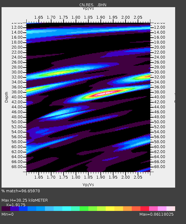
| Estimated Moho Depth: |
38.25 km |
| Estimated Crust Vp/Vs: |
1.92 |
| Assumed Crust Vp: |
6.367 km/s |
| Estimated Crust Vs: |
3.32 km/s |
| Estimated Crust Poisson's Ratio: |
0.31 |
|
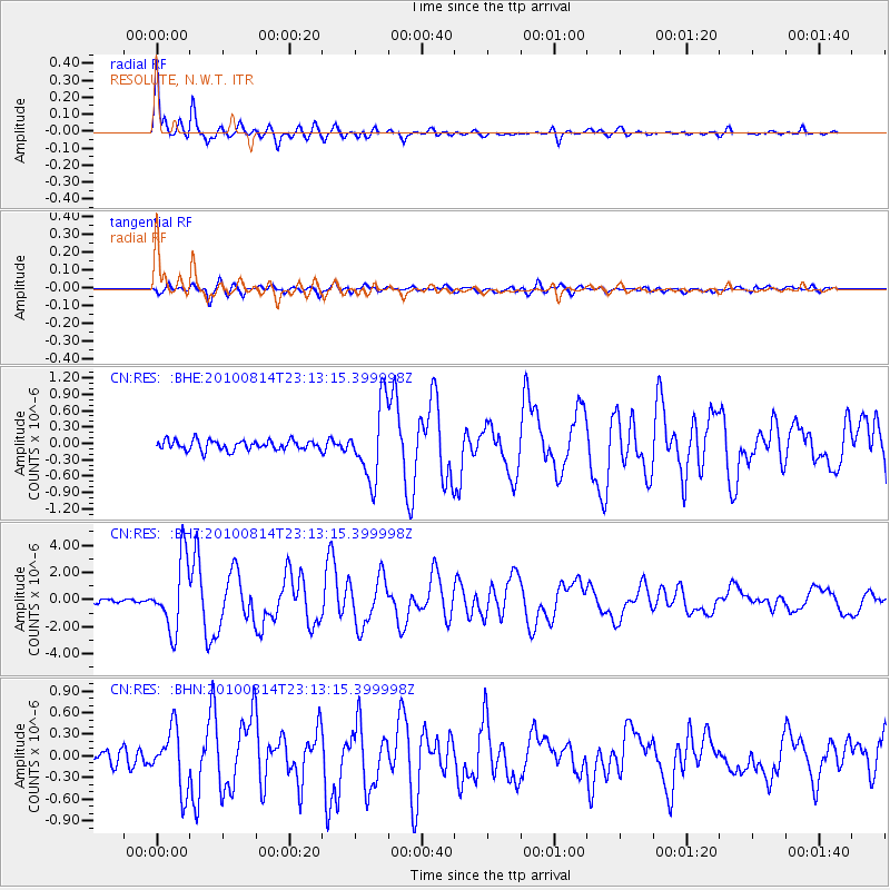
| Radial Match: |
96.65978 % |
| Radial Bump: |
306 |
| Transverse Match: |
83.65854 % |
| Transverse Bump: |
400 |
| SOD ConfigId: |
319893 |
| Insert Time: |
2011-01-05 22:59:18.777 +0000 |
| GWidth: |
2.5 |
| Max Bumps: |
400 |
| Tol: |
0.001 |
|
Signal To Noise
| Channel | StoN | STA | LTA |
| CN:RES: :BHZ:20100814T23:13:15.399998Z | 18.933155 | 2.5652614E-6 | 1.3549044E-7 |
| CN:RES: :BHN:20100814T23:13:15.399998Z | 3.757649 | 4.1023785E-7 | 1.09174074E-7 |
| CN:RES: :BHE:20100814T23:13:15.399998Z | 7.4599457 | 6.7528583E-7 | 9.0521546E-8 |
| Arrivals |
| Ps | 5.6 SECOND |
| PpPs | 17 SECOND |
| PsPs/PpSs | 23 SECOND |


