You are here: Home > Network List > CN - Canadian National Seismograph Network Stations List
> Station YKW3 > Earthquake Result Viewer
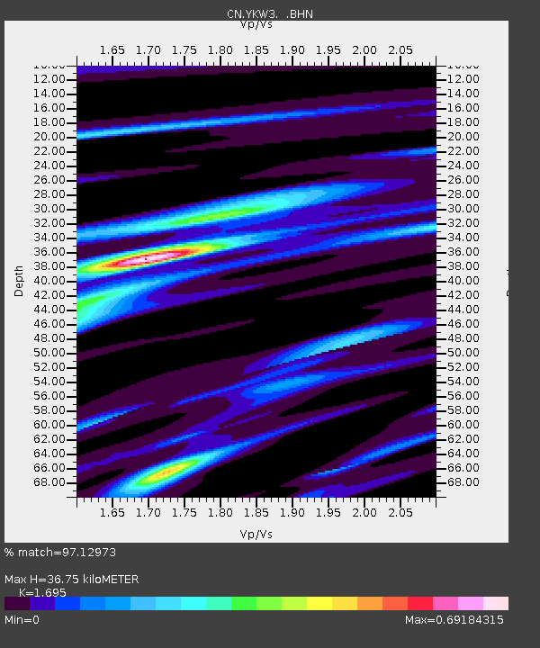
YKW3 - Earthquake Result Viewer
| Earthquake location: |
South Of Mariana Islands |
| Earthquake latitude/longitude: |
12.3/141.4 |
| Earthquake time(UTC): |
2010/08/14 (226) 23:01:04 GMT |
| Earthquake Depth: |
13 km |
| Earthquake Magnitude: |
6.1 MB, 6.3 MS, 6.6 MW, 6.3 MW |
| Earthquake Catalog/Contributor: |
WHDF/NEIC |
|
| Network: |
CN Canadian National Seismograph Network |
| Station: |
YKW3 |
| Lat/Lon: |
62.56 N/114.62 W |
| Elevation: |
200 m |
|
| Distance: |
85.5 deg |
| Az: |
26.805 deg |
| Baz: |
287.919 deg |
| Ray Param: |
0.044695184 |
| Estimated Moho Depth: |
36.75 km |
| Estimated Crust Vp/Vs: |
1.70 |
| Assumed Crust Vp: |
6.459 km/s |
| Estimated Crust Vs: |
3.811 km/s |
| Estimated Crust Poisson's Ratio: |
0.23 |
|
| Radial Match: |
97.12973 % |
| Radial Bump: |
274 |
| Transverse Match: |
84.65817 % |
| Transverse Bump: |
400 |
| SOD ConfigId: |
319893 |
| Insert Time: |
2011-01-05 22:59:35.657 +0000 |
| GWidth: |
2.5 |
| Max Bumps: |
400 |
| Tol: |
0.001 |
|

Signal To Noise
| Channel | StoN | STA | LTA |
| CN:YKW3: :BHZ:20100814T23:13:10.249973Z | 22.626968 | 3.3168103E-8 | 1.465866E-9 |
| CN:YKW3: :BHN:20100814T23:13:10.249973Z | 5.180707 | 3.9092063E-9 | 7.5457E-10 |
| CN:YKW3: :BHE:20100814T23:13:10.249973Z | 9.084268 | 1.0498507E-8 | 1.1556801E-9 |
| Arrivals |
| Ps | 4.1 SECOND |
| PpPs | 15 SECOND |
| PsPs/PpSs | 19 SECOND |


