You are here: Home > Network List > IU - Global Seismograph Network (GSN - IRIS/USGS) Stations List
> Station YAK Yakutsk, Russia > Earthquake Result Viewer
YAK Yakutsk, Russia - Earthquake Result Viewer
| Earthquake location: |
South Of Mariana Islands |
| Earthquake latitude/longitude: |
12.3/141.4 |
| Earthquake time(UTC): |
2010/08/14 (226) 23:01:04 GMT |
| Earthquake Depth: |
13 km |
| Earthquake Magnitude: |
6.1 MB, 6.3 MS, 6.6 MW, 6.3 MW |
| Earthquake Catalog/Contributor: |
WHDF/NEIC |
|
| Network: |
IU Global Seismograph Network (GSN - IRIS/USGS) |
| Station: |
YAK Yakutsk, Russia |
| Lat/Lon: |
62.03 N/129.68 E |
| Elevation: |
110 m |
|
| Distance: |
50.4 deg |
| Az: |
352.843 deg |
| Baz: |
165.031 deg |
| Ray Param: |
0.06807552 |
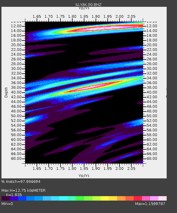
| Estimated Moho Depth: |
12.75 km |
| Estimated Crust Vp/Vs: |
1.93 |
| Assumed Crust Vp: |
6.273 km/s |
| Estimated Crust Vs: |
3.242 km/s |
| Estimated Crust Poisson's Ratio: |
0.32 |
|
| Radial Match: |
97.986694 % |
| Radial Bump: |
341 |
| Transverse Match: |
87.75105 % |
| Transverse Bump: |
400 |
| SOD ConfigId: |
319893 |
| Insert Time: |
2011-01-05 23:01:26.106 +0000 |
| GWidth: |
2.5 |
| Max Bumps: |
400 |
| Tol: |
0.001 |
|
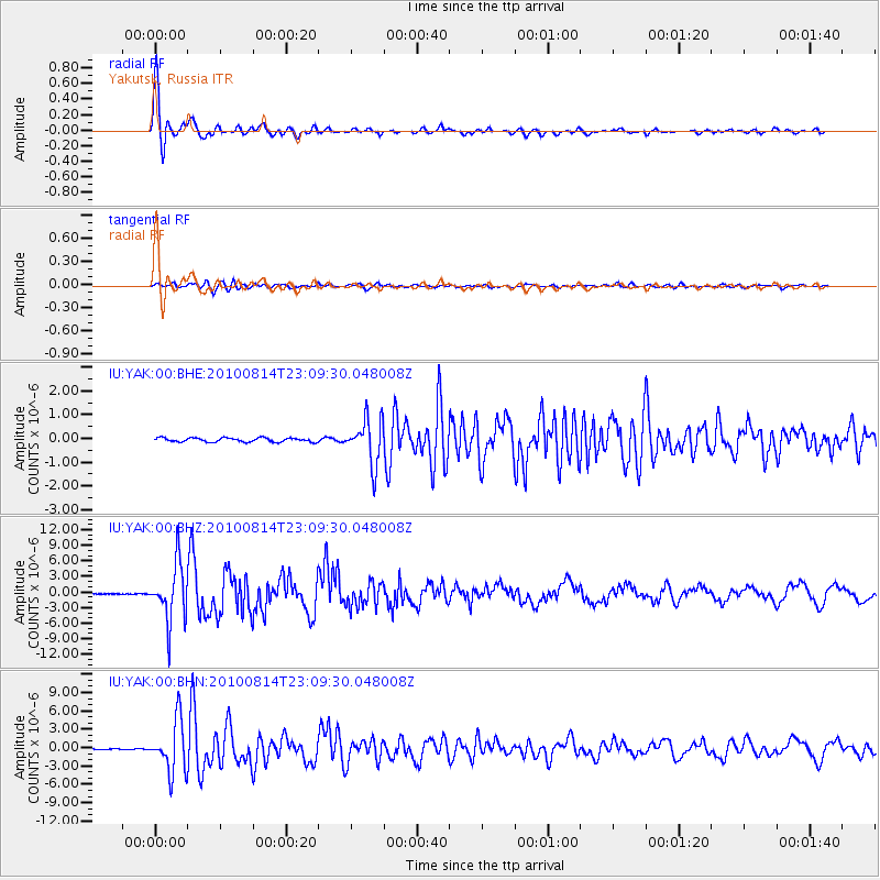
Signal To Noise
| Channel | StoN | STA | LTA |
| IU:YAK:00:BHZ:20100814T23:09:30.048008Z | 88.23669 | 5.459135E-6 | 6.186922E-8 |
| IU:YAK:00:BHN:20100814T23:09:30.048008Z | 82.656334 | 4.2142465E-6 | 5.0985157E-8 |
| IU:YAK:00:BHE:20100814T23:09:30.048008Z | 10.783194 | 9.3352304E-7 | 8.657204E-8 |
| Arrivals |
| Ps | 2.0 SECOND |
| PpPs | 5.7 SECOND |
| PsPs/PpSs | 7.7 SECOND |


