You are here: Home > Network List > IW - Intermountain West Stations List
> Station MOOW Moose Ponds, Wyoming, USA > Earthquake Result Viewer
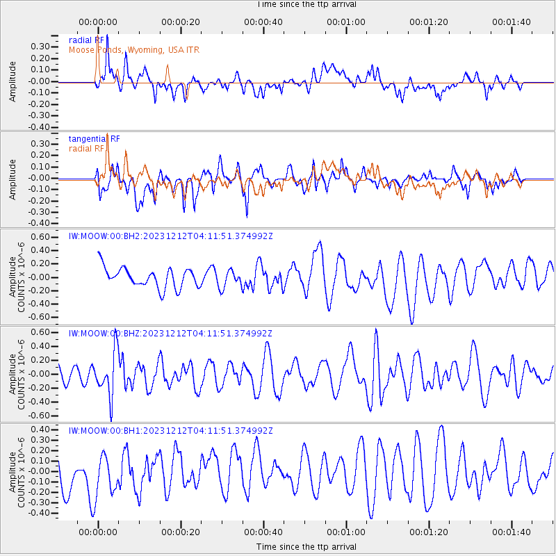
MOOW Moose Ponds, Wyoming, USA - Earthquake Result Viewer
*The percent match for this event was below the threshold and hence no stack was calculated.
| Earthquake location: |
Tonga Islands |
| Earthquake latitude/longitude: |
-18.0/-175.3 |
| Earthquake time(UTC): |
2023/12/12 (346) 04:00:15 GMT |
| Earthquake Depth: |
261 km |
| Earthquake Magnitude: |
5.8 Mww |
| Earthquake Catalog/Contributor: |
NEIC PDE/us |
|
| Network: |
IW Intermountain West |
| Station: |
MOOW Moose Ponds, Wyoming, USA |
| Lat/Lon: |
43.75 N/110.74 W |
| Elevation: |
2128 m |
|
| Distance: |
85.2 deg |
| Az: |
41.056 deg |
| Baz: |
239.581 deg |
| Ray Param: |
$rayparam |
*The percent match for this event was below the threshold and hence was not used in the summary stack. |
|
| Radial Match: |
37.336994 % |
| Radial Bump: |
400 |
| Transverse Match: |
51.596436 % |
| Transverse Bump: |
400 |
| SOD ConfigId: |
33232451 |
| Insert Time: |
2023-12-26 04:17:44.771 +0000 |
| GWidth: |
2.5 |
| Max Bumps: |
400 |
| Tol: |
0.001 |
|
Signal To Noise
| Channel | StoN | STA | LTA |
| IW:MOOW:00:BHZ:20231212T04:11:51.374992Z | 1.7763358 | 3.2737046E-7 | 1.8429536E-7 |
| IW:MOOW:00:BH1:20231212T04:11:51.374992Z | 1.2057452 | 2.0229925E-7 | 1.6777943E-7 |
| IW:MOOW:00:BH2:20231212T04:11:51.374992Z | 0.8815279 | 1.3057182E-7 | 1.481199E-7 |
| Arrivals |
| Ps | |
| PpPs | |
| PsPs/PpSs | |


