You are here: Home > Network List > US - United States National Seismic Network Stations List
> Station AGMN Agassiz National Wildlife Refuge, Minnesota, USA > Earthquake Result Viewer
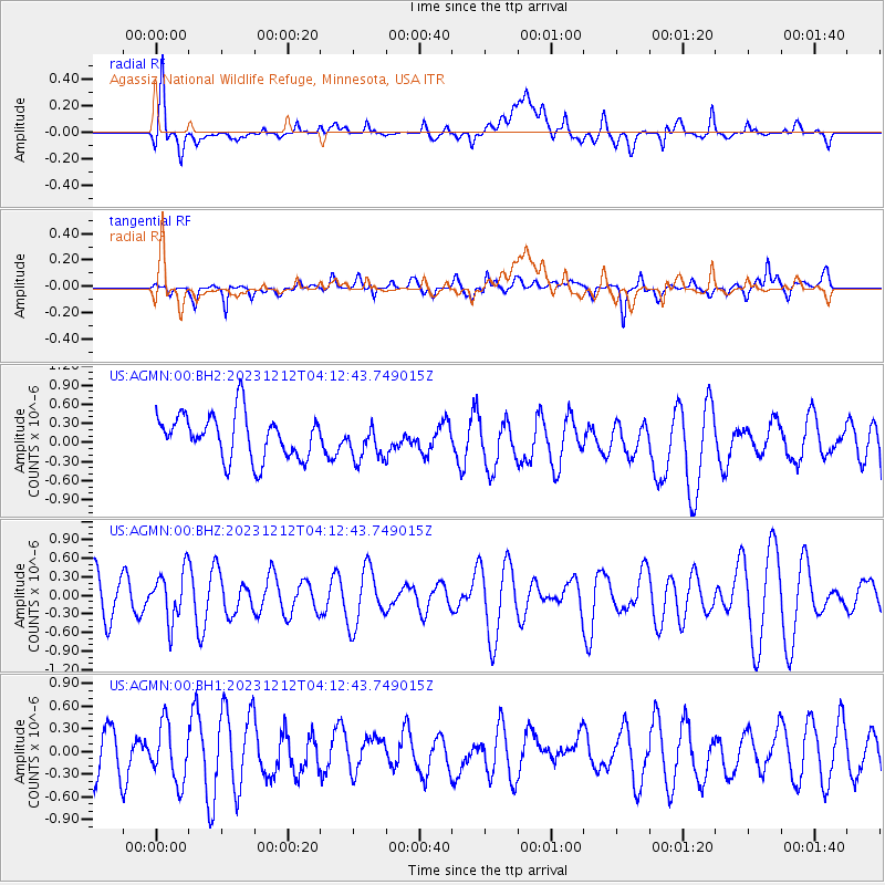
AGMN Agassiz National Wildlife Refuge, Minnesota, USA - Earthquake Result Viewer
*The percent match for this event was below the threshold and hence no stack was calculated.
| Earthquake location: |
Tonga Islands |
| Earthquake latitude/longitude: |
-18.0/-175.3 |
| Earthquake time(UTC): |
2023/12/12 (346) 04:00:15 GMT |
| Earthquake Depth: |
261 km |
| Earthquake Magnitude: |
5.8 Mww |
| Earthquake Catalog/Contributor: |
NEIC PDE/us |
|
| Network: |
US United States National Seismic Network |
| Station: |
AGMN Agassiz National Wildlife Refuge, Minnesota, USA |
| Lat/Lon: |
48.30 N/95.86 W |
| Elevation: |
351 m |
|
| Distance: |
96.5 deg |
| Az: |
41.351 deg |
| Baz: |
250.29 deg |
| Ray Param: |
$rayparam |
*The percent match for this event was below the threshold and hence was not used in the summary stack. |
|
| Radial Match: |
66.82079 % |
| Radial Bump: |
400 |
| Transverse Match: |
64.677 % |
| Transverse Bump: |
400 |
| SOD ConfigId: |
33232451 |
| Insert Time: |
2023-12-26 04:27:54.524 +0000 |
| GWidth: |
2.5 |
| Max Bumps: |
400 |
| Tol: |
0.001 |
|
Signal To Noise
| Channel | StoN | STA | LTA |
| US:AGMN:00:BHZ:20231212T04:12:43.749015Z | 0.954141 | 4.0843832E-7 | 4.2806914E-7 |
| US:AGMN:00:BH1:20231212T04:12:43.749015Z | 1.3161242 | 3.7139495E-7 | 2.8218838E-7 |
| US:AGMN:00:BH2:20231212T04:12:43.749015Z | 0.81432444 | 2.8298606E-7 | 3.4751022E-7 |
| Arrivals |
| Ps | |
| PpPs | |
| PsPs/PpSs | |


