You are here: Home > Network List > US - United States National Seismic Network Stations List
> Station EGMT Eagleton, Montana, USA > Earthquake Result Viewer
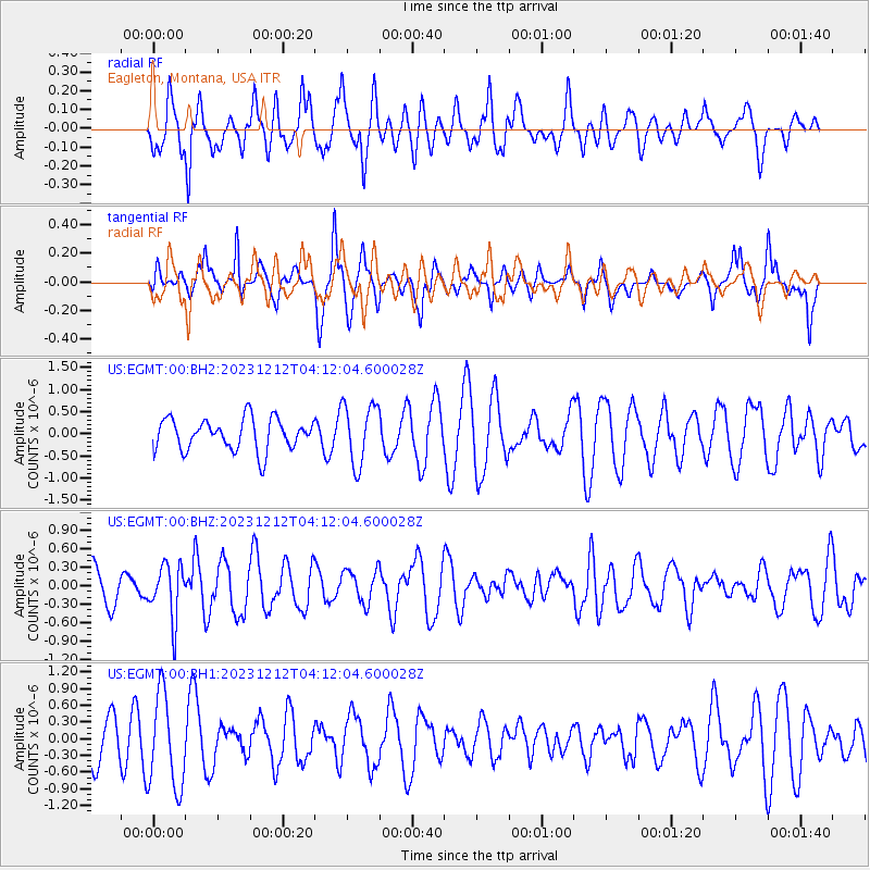
EGMT Eagleton, Montana, USA - Earthquake Result Viewer
*The percent match for this event was below the threshold and hence no stack was calculated.
| Earthquake location: |
Tonga Islands |
| Earthquake latitude/longitude: |
-18.0/-175.3 |
| Earthquake time(UTC): |
2023/12/12 (346) 04:00:15 GMT |
| Earthquake Depth: |
261 km |
| Earthquake Magnitude: |
5.8 Mww |
| Earthquake Catalog/Contributor: |
NEIC PDE/us |
|
| Network: |
US United States National Seismic Network |
| Station: |
EGMT Eagleton, Montana, USA |
| Lat/Lon: |
48.02 N/109.75 W |
| Elevation: |
1055 m |
|
| Distance: |
87.9 deg |
| Az: |
37.701 deg |
| Baz: |
240.088 deg |
| Ray Param: |
$rayparam |
*The percent match for this event was below the threshold and hence was not used in the summary stack. |
|
| Radial Match: |
44.389214 % |
| Radial Bump: |
362 |
| Transverse Match: |
54.45436 % |
| Transverse Bump: |
308 |
| SOD ConfigId: |
33232451 |
| Insert Time: |
2023-12-26 04:28:05.299 +0000 |
| GWidth: |
2.5 |
| Max Bumps: |
400 |
| Tol: |
0.001 |
|
Signal To Noise
| Channel | StoN | STA | LTA |
| US:EGMT:00:BHZ:20231212T04:12:04.600028Z | 1.8539342 | 4.3908466E-7 | 2.368394E-7 |
| US:EGMT:00:BH1:20231212T04:12:04.600028Z | 2.2974036 | 8.346469E-7 | 3.6330007E-7 |
| US:EGMT:00:BH2:20231212T04:12:04.600028Z | 1.9330678 | 6.8840905E-7 | 3.5612254E-7 |
| Arrivals |
| Ps | |
| PpPs | |
| PsPs/PpSs | |


