You are here: Home > Network List > TA - USArray Transportable Network (new EarthScope stations) Stations List
> Station J23A Dilts Ranch, Bill, WY, USA > Earthquake Result Viewer
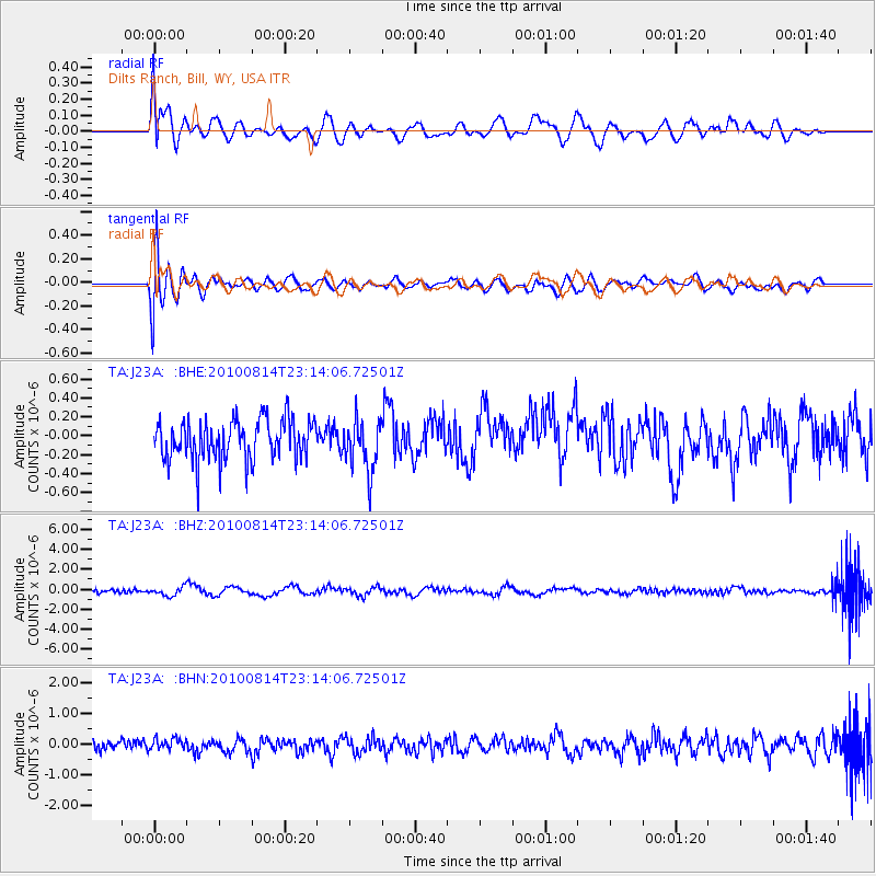
J23A Dilts Ranch, Bill, WY, USA - Earthquake Result Viewer
*The percent match for this event was below the threshold and hence no stack was calculated.
| Earthquake location: |
South Of Mariana Islands |
| Earthquake latitude/longitude: |
12.3/141.4 |
| Earthquake time(UTC): |
2010/08/14 (226) 23:01:04 GMT |
| Earthquake Depth: |
13 km |
| Earthquake Magnitude: |
6.1 MB, 6.3 MS, 6.6 MW, 6.3 MW |
| Earthquake Catalog/Contributor: |
WHDF/NEIC |
|
| Network: |
TA USArray Transportable Network (new EarthScope stations) |
| Station: |
J23A Dilts Ranch, Bill, WY, USA |
| Lat/Lon: |
43.40 N/105.55 W |
| Elevation: |
1499 m |
|
| Distance: |
97.7 deg |
| Az: |
42.602 deg |
| Baz: |
294.797 deg |
| Ray Param: |
$rayparam |
*The percent match for this event was below the threshold and hence was not used in the summary stack. |
|
| Radial Match: |
59.071316 % |
| Radial Bump: |
400 |
| Transverse Match: |
69.18022 % |
| Transverse Bump: |
400 |
| SOD ConfigId: |
319893 |
| Insert Time: |
2011-01-05 23:07:28.562 +0000 |
| GWidth: |
2.5 |
| Max Bumps: |
400 |
| Tol: |
0.001 |
|
Signal To Noise
| Channel | StoN | STA | LTA |
| TA:J23A: :BHZ:20100814T23:14:06.72501Z | 2.3170555 | 4.248505E-7 | 1.8335794E-7 |
| TA:J23A: :BHN:20100814T23:14:06.72501Z | 0.9914721 | 1.9575938E-7 | 1.9744316E-7 |
| TA:J23A: :BHE:20100814T23:14:06.72501Z | 1.2829528 | 2.7092798E-7 | 2.1117533E-7 |
| Arrivals |
| Ps | |
| PpPs | |
| PsPs/PpSs | |


