You are here: Home > Network List > UW - Pacific Northwest Regional Seismic Network Stations List
> Station IRON Crane, OR, USA > Earthquake Result Viewer
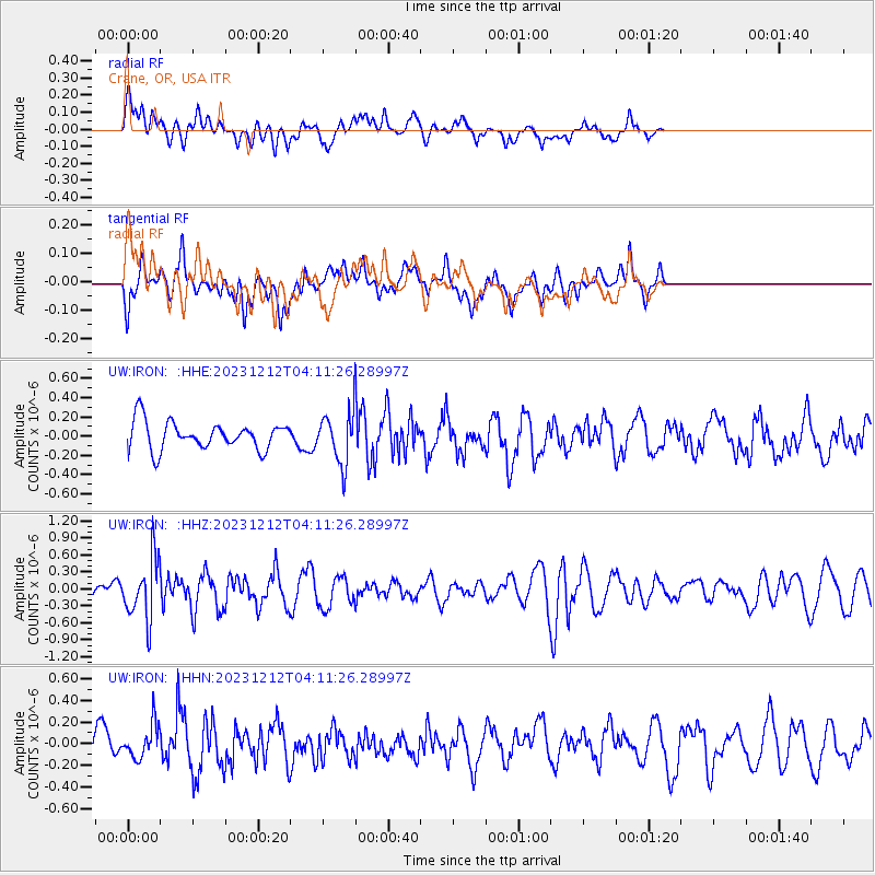
IRON Crane, OR, USA - Earthquake Result Viewer
*The percent match for this event was below the threshold and hence no stack was calculated.
| Earthquake location: |
Tonga Islands |
| Earthquake latitude/longitude: |
-18.0/-175.3 |
| Earthquake time(UTC): |
2023/12/12 (346) 04:00:15 GMT |
| Earthquake Depth: |
261 km |
| Earthquake Magnitude: |
5.8 Mww |
| Earthquake Catalog/Contributor: |
NEIC PDE/us |
|
| Network: |
UW Pacific Northwest Regional Seismic Network |
| Station: |
IRON Crane, OR, USA |
| Lat/Lon: |
43.36 N/118.47 W |
| Elevation: |
1226 m |
|
| Distance: |
80.3 deg |
| Az: |
38.28 deg |
| Baz: |
233.918 deg |
| Ray Param: |
$rayparam |
*The percent match for this event was below the threshold and hence was not used in the summary stack. |
|
| Radial Match: |
46.97508 % |
| Radial Bump: |
400 |
| Transverse Match: |
51.44752 % |
| Transverse Bump: |
378 |
| SOD ConfigId: |
33232451 |
| Insert Time: |
2023-12-26 04:30:13.464 +0000 |
| GWidth: |
2.5 |
| Max Bumps: |
400 |
| Tol: |
0.001 |
|
Signal To Noise
| Channel | StoN | STA | LTA |
| UW:IRON: :HHZ:20231212T04:11:26.28997Z | 2.5040514 | 5.2217945E-7 | 2.0853382E-7 |
| UW:IRON: :HHN:20231212T04:11:26.28997Z | 1.0207045 | 1.5350766E-7 | 1.5039383E-7 |
| UW:IRON: :HHE:20231212T04:11:26.28997Z | 1.7734964 | 2.5713805E-7 | 1.4498933E-7 |
| Arrivals |
| Ps | |
| PpPs | |
| PsPs/PpSs | |


