You are here: Home > Network List > TA - USArray Transportable Network (new EarthScope stations) Stations List
> Station A27A Ledoux Ranch, Antler, ND, USA > Earthquake Result Viewer
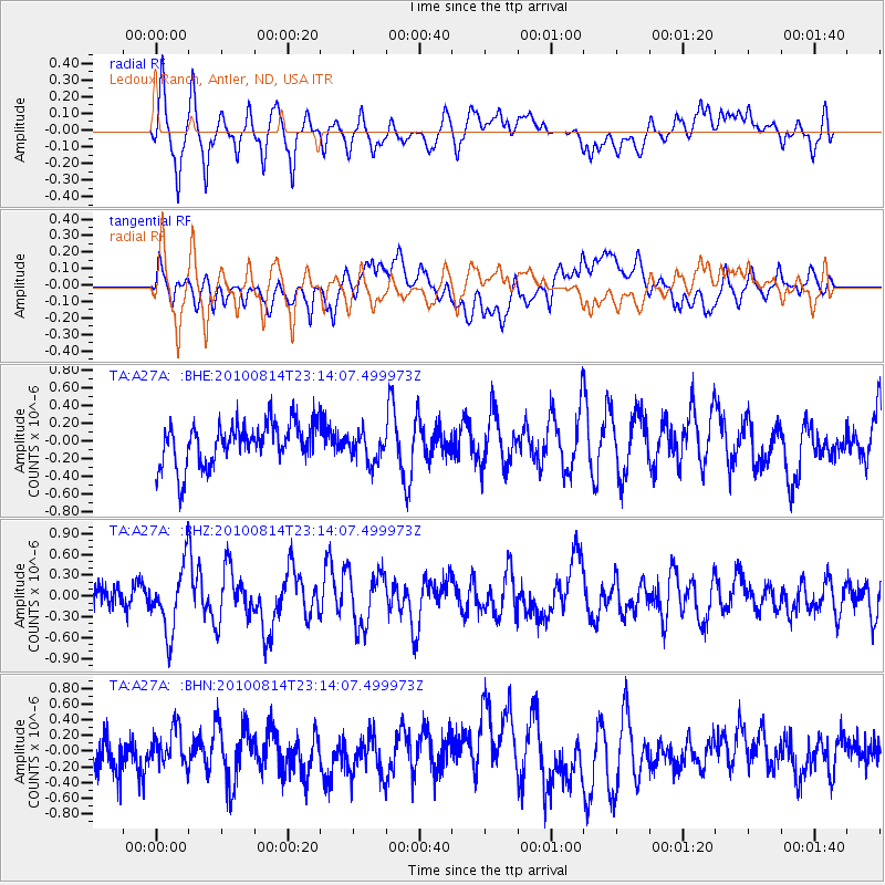
A27A Ledoux Ranch, Antler, ND, USA - Earthquake Result Viewer
*The percent match for this event was below the threshold and hence no stack was calculated.
| Earthquake location: |
South Of Mariana Islands |
| Earthquake latitude/longitude: |
12.3/141.4 |
| Earthquake time(UTC): |
2010/08/14 (226) 23:01:04 GMT |
| Earthquake Depth: |
13 km |
| Earthquake Magnitude: |
6.1 MB, 6.3 MS, 6.6 MW, 6.3 MW |
| Earthquake Catalog/Contributor: |
WHDF/NEIC |
|
| Network: |
TA USArray Transportable Network (new EarthScope stations) |
| Station: |
A27A Ledoux Ranch, Antler, ND, USA |
| Lat/Lon: |
48.95 N/101.24 W |
| Elevation: |
466 m |
|
| Distance: |
97.9 deg |
| Az: |
36.24 deg |
| Baz: |
298.765 deg |
| Ray Param: |
$rayparam |
*The percent match for this event was below the threshold and hence was not used in the summary stack. |
|
| Radial Match: |
70.7587 % |
| Radial Bump: |
400 |
| Transverse Match: |
55.91161 % |
| Transverse Bump: |
400 |
| SOD ConfigId: |
319893 |
| Insert Time: |
2011-01-05 23:08:32.734 +0000 |
| GWidth: |
2.5 |
| Max Bumps: |
400 |
| Tol: |
0.001 |
|
Signal To Noise
| Channel | StoN | STA | LTA |
| TA:A27A: :BHZ:20100814T23:14:07.499973Z | 2.9996986 | 4.6856516E-7 | 1.5620408E-7 |
| TA:A27A: :BHN:20100814T23:14:07.499973Z | 0.85068214 | 2.4770358E-7 | 2.9118232E-7 |
| TA:A27A: :BHE:20100814T23:14:07.499973Z | 0.6980142 | 1.6677707E-7 | 2.3893077E-7 |
| Arrivals |
| Ps | |
| PpPs | |
| PsPs/PpSs | |


