You are here: Home > Network List > TA - USArray Transportable Network (new EarthScope stations) Stations List
> Station I05D Terrebonne, OR, USA > Earthquake Result Viewer
I05D Terrebonne, OR, USA - Earthquake Result Viewer
| Earthquake location: |
South Of Mariana Islands |
| Earthquake latitude/longitude: |
12.3/141.4 |
| Earthquake time(UTC): |
2010/08/14 (226) 23:01:04 GMT |
| Earthquake Depth: |
13 km |
| Earthquake Magnitude: |
6.1 MB, 6.3 MS, 6.6 MW, 6.3 MW |
| Earthquake Catalog/Contributor: |
WHDF/NEIC |
|
| Network: |
TA USArray Transportable Network (new EarthScope stations) |
| Station: |
I05D Terrebonne, OR, USA |
| Lat/Lon: |
44.34 N/121.34 W |
| Elevation: |
1546 m |
|
| Distance: |
86.6 deg |
| Az: |
45.487 deg |
| Baz: |
283.749 deg |
| Ray Param: |
0.0439087 |
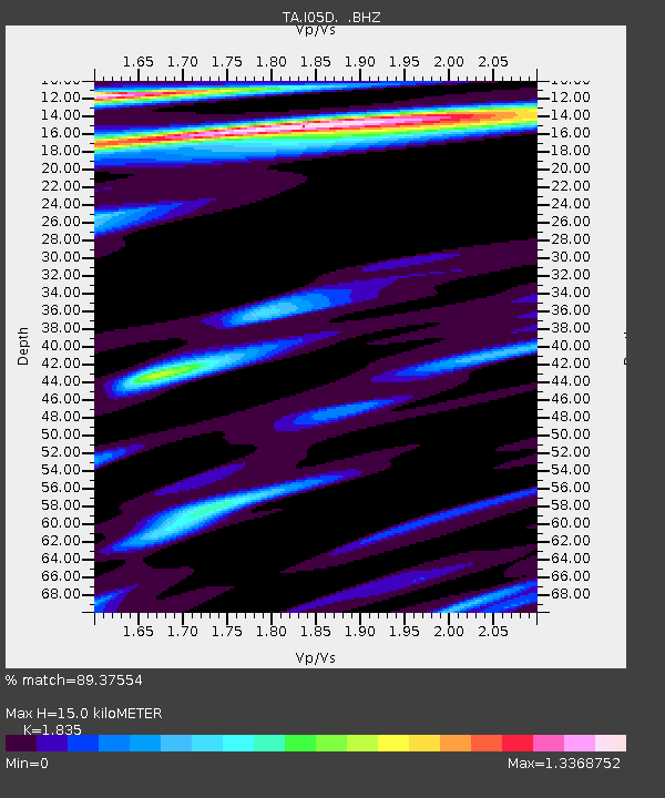
| Estimated Moho Depth: |
15.0 km |
| Estimated Crust Vp/Vs: |
1.84 |
| Assumed Crust Vp: |
6.597 km/s |
| Estimated Crust Vs: |
3.595 km/s |
| Estimated Crust Poisson's Ratio: |
0.29 |
|
| Radial Match: |
89.37554 % |
| Radial Bump: |
400 |
| Transverse Match: |
81.51046 % |
| Transverse Bump: |
400 |
| SOD ConfigId: |
319893 |
| Insert Time: |
2011-01-05 23:08:58.414 +0000 |
| GWidth: |
2.5 |
| Max Bumps: |
400 |
| Tol: |
0.001 |
|

Signal To Noise
| Channel | StoN | STA | LTA |
| TA:I05D: :BHZ:20100814T23:13:15.624973Z | 7.422824 | 1.2695729E-6 | 1.7103636E-7 |
| TA:I05D: :BHN:20100814T23:13:15.624973Z | 0.94258237 | 1.5527411E-7 | 1.6473267E-7 |
| TA:I05D: :BHE:20100814T23:13:15.624973Z | 2.8051412 | 4.9359824E-7 | 1.7596201E-7 |
| Arrivals |
| Ps | 1.9 SECOND |
| PpPs | 6.3 SECOND |
| PsPs/PpSs | 8.2 SECOND |


