You are here: Home > Network List > TA - USArray Transportable Network (new EarthScope stations) Stations List
> Station O03D Paynes Creek, CA, USA > Earthquake Result Viewer
O03D Paynes Creek, CA, USA - Earthquake Result Viewer
| Earthquake location: |
South Of Mariana Islands |
| Earthquake latitude/longitude: |
12.3/141.4 |
| Earthquake time(UTC): |
2010/08/14 (226) 23:01:04 GMT |
| Earthquake Depth: |
13 km |
| Earthquake Magnitude: |
6.1 MB, 6.3 MS, 6.6 MW, 6.3 MW |
| Earthquake Catalog/Contributor: |
WHDF/NEIC |
|
| Network: |
TA USArray Transportable Network (new EarthScope stations) |
| Station: |
O03D Paynes Creek, CA, USA |
| Lat/Lon: |
40.29 N/121.80 W |
| Elevation: |
968 m |
|
| Distance: |
87.3 deg |
| Az: |
49.5 deg |
| Baz: |
283.653 deg |
| Ray Param: |
0.043451242 |
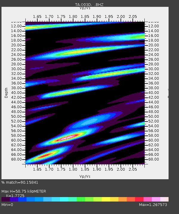
| Estimated Moho Depth: |
58.75 km |
| Estimated Crust Vp/Vs: |
1.77 |
| Assumed Crust Vp: |
6.566 km/s |
| Estimated Crust Vs: |
3.704 km/s |
| Estimated Crust Poisson's Ratio: |
0.27 |
|
| Radial Match: |
90.15841 % |
| Radial Bump: |
400 |
| Transverse Match: |
79.52431 % |
| Transverse Bump: |
400 |
| SOD ConfigId: |
319893 |
| Insert Time: |
2011-01-05 23:09:59.676 +0000 |
| GWidth: |
2.5 |
| Max Bumps: |
400 |
| Tol: |
0.001 |
|
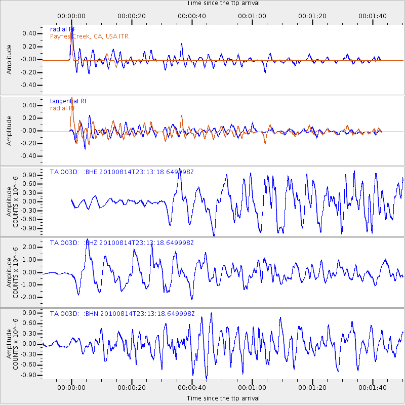
Signal To Noise
| Channel | StoN | STA | LTA |
| TA:O03D: :BHZ:20100814T23:13:18.649998Z | 17.152853 | 8.4186183E-7 | 4.907999E-8 |
| TA:O03D: :BHN:20100814T23:13:18.649998Z | 1.545458 | 1.4220961E-7 | 9.201778E-8 |
| TA:O03D: :BHE:20100814T23:13:18.649998Z | 3.4453332 | 3.3870555E-7 | 9.8308504E-8 |
| Arrivals |
| Ps | 7.1 SECOND |
| PpPs | 24 SECOND |
| PsPs/PpSs | 31 SECOND |


