You are here: Home > Network List > US - United States National Seismic Network Stations List
> Station DGMT Dagmar, Montana, USA > Earthquake Result Viewer
DGMT Dagmar, Montana, USA - Earthquake Result Viewer
*The percent match for this event was below the threshold and hence no stack was calculated.
| Earthquake location: |
South Of Mariana Islands |
| Earthquake latitude/longitude: |
12.3/141.4 |
| Earthquake time(UTC): |
2010/08/14 (226) 23:01:04 GMT |
| Earthquake Depth: |
13 km |
| Earthquake Magnitude: |
6.1 MB, 6.3 MS, 6.6 MW, 6.3 MW |
| Earthquake Catalog/Contributor: |
WHDF/NEIC |
|
| Network: |
US United States National Seismic Network |
| Station: |
DGMT Dagmar, Montana, USA |
| Lat/Lon: |
48.47 N/104.20 W |
| Elevation: |
0.0 m |
|
| Distance: |
96.4 deg |
| Az: |
37.585 deg |
| Baz: |
296.385 deg |
| Ray Param: |
$rayparam |
*The percent match for this event was below the threshold and hence was not used in the summary stack. |
|
| Radial Match: |
66.90403 % |
| Radial Bump: |
388 |
| Transverse Match: |
52.940144 % |
| Transverse Bump: |
400 |
| SOD ConfigId: |
319893 |
| Insert Time: |
2011-01-05 23:11:54.991 +0000 |
| GWidth: |
2.5 |
| Max Bumps: |
400 |
| Tol: |
0.001 |
|
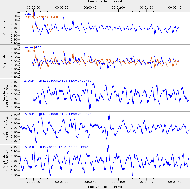
Signal To Noise
| Channel | StoN | STA | LTA |
| US:DGMT: :BHZ:20100814T23:14:00.749973Z | 6.990877 | 6.061949E-7 | 8.6712284E-8 |
| US:DGMT: :BHN:20100814T23:14:00.749973Z | 1.4942213 | 2.85767E-7 | 1.912481E-7 |
| US:DGMT: :BHE:20100814T23:14:00.749973Z | 0.80026 | 1.6091228E-7 | 2.0107498E-7 |
| Arrivals |
| Ps | |
| PpPs | |
| PsPs/PpSs | |


