You are here: Home > Network List > US - United States National Seismic Network Stations List
> Station LAO LASA Array, Montana, USA > Earthquake Result Viewer
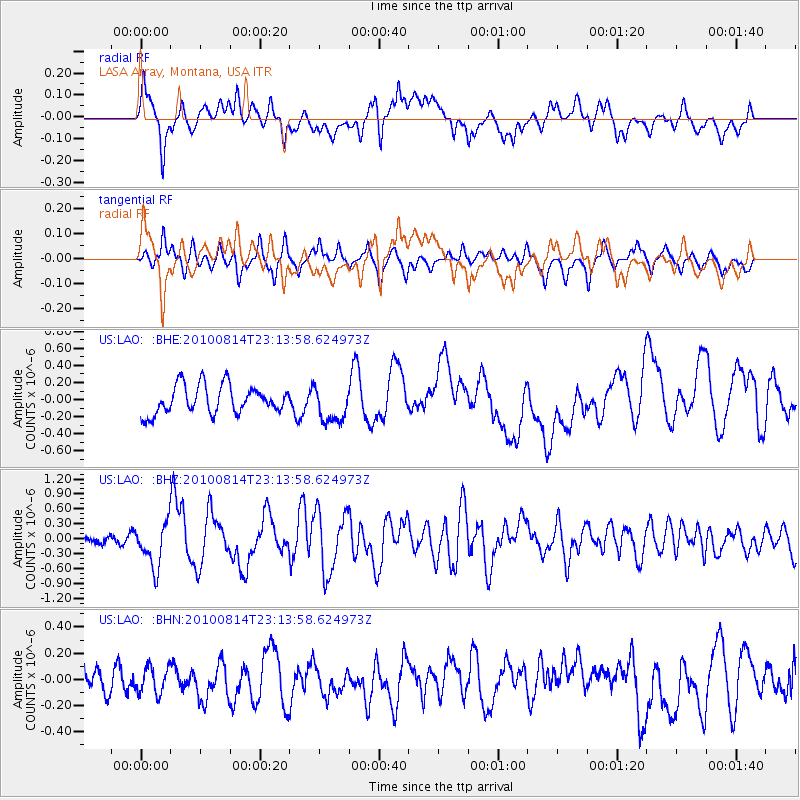
LAO LASA Array, Montana, USA - Earthquake Result Viewer
*The percent match for this event was below the threshold and hence no stack was calculated.
| Earthquake location: |
South Of Mariana Islands |
| Earthquake latitude/longitude: |
12.3/141.4 |
| Earthquake time(UTC): |
2010/08/14 (226) 23:01:04 GMT |
| Earthquake Depth: |
13 km |
| Earthquake Magnitude: |
6.1 MB, 6.3 MS, 6.6 MW, 6.3 MW |
| Earthquake Catalog/Contributor: |
WHDF/NEIC |
|
| Network: |
US United States National Seismic Network |
| Station: |
LAO LASA Array, Montana, USA |
| Lat/Lon: |
46.69 N/106.22 W |
| Elevation: |
902 m |
|
| Distance: |
95.9 deg |
| Az: |
39.798 deg |
| Baz: |
294.656 deg |
| Ray Param: |
$rayparam |
*The percent match for this event was below the threshold and hence was not used in the summary stack. |
|
| Radial Match: |
60.707027 % |
| Radial Bump: |
400 |
| Transverse Match: |
68.115395 % |
| Transverse Bump: |
372 |
| SOD ConfigId: |
319893 |
| Insert Time: |
2011-01-05 23:12:00.093 +0000 |
| GWidth: |
2.5 |
| Max Bumps: |
400 |
| Tol: |
0.001 |
|
Signal To Noise
| Channel | StoN | STA | LTA |
| US:LAO: :BHZ:20100814T23:13:58.624973Z | 3.671125 | 4.524375E-7 | 1.232422E-7 |
| US:LAO: :BHN:20100814T23:13:58.624973Z | 0.81020844 | 1.0143823E-7 | 1.2520016E-7 |
| US:LAO: :BHE:20100814T23:13:58.624973Z | 1.2926033 | 2.133517E-7 | 1.6505582E-7 |
| Arrivals |
| Ps | |
| PpPs | |
| PsPs/PpSs | |


