You are here: Home > Network List > UW - Pacific Northwest Regional Seismic Network Stations List
> Station FISH Seaside, OR, USA > Earthquake Result Viewer
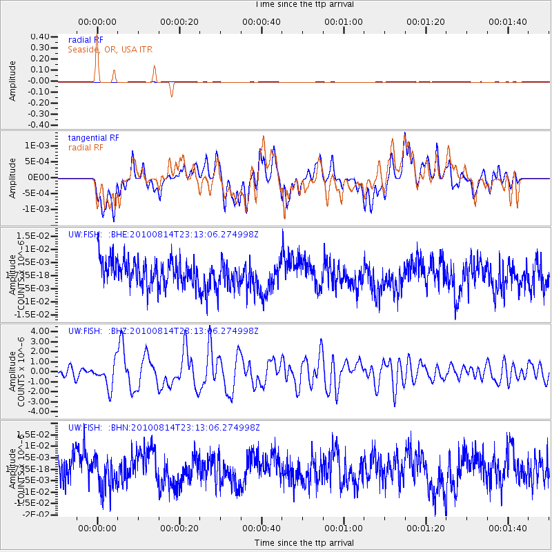
FISH Seaside, OR, USA - Earthquake Result Viewer
*The percent match for this event was below the threshold and hence no stack was calculated.
| Earthquake location: |
South Of Mariana Islands |
| Earthquake latitude/longitude: |
12.3/141.4 |
| Earthquake time(UTC): |
2010/08/14 (226) 23:01:04 GMT |
| Earthquake Depth: |
13 km |
| Earthquake Magnitude: |
6.1 MB, 6.3 MS, 6.6 MW, 6.3 MW |
| Earthquake Catalog/Contributor: |
WHDF/NEIC |
|
| Network: |
UW Pacific Northwest Regional Seismic Network |
| Station: |
FISH Seaside, OR, USA |
| Lat/Lon: |
45.93 N/123.56 W |
| Elevation: |
325 m |
|
| Distance: |
84.7 deg |
| Az: |
44.283 deg |
| Baz: |
282.09 deg |
| Ray Param: |
$rayparam |
*The percent match for this event was below the threshold and hence was not used in the summary stack. |
|
| Radial Match: |
47.768665 % |
| Radial Bump: |
400 |
| Transverse Match: |
44.293148 % |
| Transverse Bump: |
400 |
| SOD ConfigId: |
319893 |
| Insert Time: |
2011-01-05 23:12:50.043 +0000 |
| GWidth: |
2.5 |
| Max Bumps: |
400 |
| Tol: |
0.001 |
|
Signal To Noise
| Channel | StoN | STA | LTA |
| UW:FISH: :BHZ:20100814T23:13:06.274998Z | 3.1252346 | 1.3135619E-6 | 4.2030828E-7 |
| UW:FISH: :BHN:20100814T23:13:06.274998Z | 1.2195314 | 6.8003874E-9 | 5.5762293E-9 |
| UW:FISH: :BHE:20100814T23:13:06.274998Z | 1.0797945 | 5.164452E-9 | 4.7828097E-9 |
| Arrivals |
| Ps | |
| PpPs | |
| PsPs/PpSs | |


