You are here: Home > Network List > UW - Pacific Northwest Regional Seismic Network Stations List
> Station WOLL Wollman Farm, Schrag, WA, USA > Earthquake Result Viewer
WOLL Wollman Farm, Schrag, WA, USA - Earthquake Result Viewer
| Earthquake location: |
South Of Mariana Islands |
| Earthquake latitude/longitude: |
12.3/141.4 |
| Earthquake time(UTC): |
2010/08/14 (226) 23:01:04 GMT |
| Earthquake Depth: |
13 km |
| Earthquake Magnitude: |
6.1 MB, 6.3 MS, 6.6 MW, 6.3 MW |
| Earthquake Catalog/Contributor: |
WHDF/NEIC |
|
| Network: |
UW Pacific Northwest Regional Seismic Network |
| Station: |
WOLL Wollman Farm, Schrag, WA, USA |
| Lat/Lon: |
47.06 N/118.92 W |
| Elevation: |
385 m |
|
| Distance: |
87.6 deg |
| Az: |
42.426 deg |
| Baz: |
285.32 deg |
| Ray Param: |
0.043214127 |
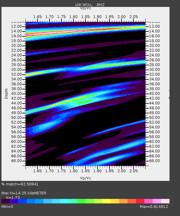
| Estimated Moho Depth: |
14.25 km |
| Estimated Crust Vp/Vs: |
1.73 |
| Assumed Crust Vp: |
6.419 km/s |
| Estimated Crust Vs: |
3.711 km/s |
| Estimated Crust Poisson's Ratio: |
0.25 |
|
| Radial Match: |
92.50941 % |
| Radial Bump: |
295 |
| Transverse Match: |
83.34175 % |
| Transverse Bump: |
400 |
| SOD ConfigId: |
319893 |
| Insert Time: |
2011-01-05 23:13:14.023 +0000 |
| GWidth: |
2.5 |
| Max Bumps: |
400 |
| Tol: |
0.001 |
|
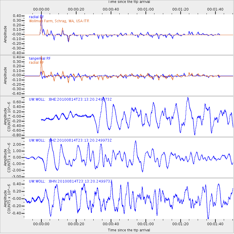
Signal To Noise
| Channel | StoN | STA | LTA |
| UW:WOLL: :BHZ:20100814T23:13:20.249973Z | 8.953002 | 1.0583009E-6 | 1.1820626E-7 |
| UW:WOLL: :BHN:20100814T23:13:20.249973Z | 1.668636 | 1.2876872E-7 | 7.717004E-8 |
| UW:WOLL: :BHE:20100814T23:13:20.249973Z | 3.664049 | 3.3250473E-7 | 9.0747896E-8 |
| Arrivals |
| Ps | 1.7 SECOND |
| PpPs | 5.9 SECOND |
| PsPs/PpSs | 7.6 SECOND |


