You are here: Home > Network List > LD - Lamont-Doherty Cooperative Seismographic Network Stations List
> Station MMNY Mount Morris Dam, NY > Earthquake Result Viewer
MMNY Mount Morris Dam, NY - Earthquake Result Viewer
| Earthquake location: |
Revilla Gigedo Islands Region |
| Earthquake latitude/longitude: |
19.9/-109.3 |
| Earthquake time(UTC): |
2023/11/24 (328) 19:26:03 GMT |
| Earthquake Depth: |
10 km |
| Earthquake Magnitude: |
5.5 mww |
| Earthquake Catalog/Contributor: |
NEIC PDE/us |
|
| Network: |
LD Lamont-Doherty Cooperative Seismographic Network |
| Station: |
MMNY Mount Morris Dam, NY |
| Lat/Lon: |
42.73 N/77.91 W |
| Elevation: |
241 m |
|
| Distance: |
34.9 deg |
| Az: |
42.154 deg |
| Baz: |
239.015 deg |
| Ray Param: |
0.07752572 |
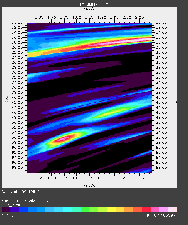
| Estimated Moho Depth: |
16.75 km |
| Estimated Crust Vp/Vs: |
2.05 |
| Assumed Crust Vp: |
6.476 km/s |
| Estimated Crust Vs: |
3.159 km/s |
| Estimated Crust Poisson's Ratio: |
0.34 |
|
| Radial Match: |
80.40541 % |
| Radial Bump: |
400 |
| Transverse Match: |
47.22461 % |
| Transverse Bump: |
400 |
| SOD ConfigId: |
33437571 |
| Insert Time: |
2023-12-26 13:42:12.843 +0000 |
| GWidth: |
2.5 |
| Max Bumps: |
400 |
| Tol: |
0.001 |
|

Signal To Noise
| Channel | StoN | STA | LTA |
| LD:MMNY: :HHZ:20231124T19:32:23.994994Z | 0.91217804 | 4.9044206E-7 | 5.3766047E-7 |
| LD:MMNY: :HHN:20231124T19:32:23.994994Z | 0.8297303 | 4.172934E-7 | 5.029265E-7 |
| LD:MMNY: :HHE:20231124T19:32:23.994994Z | 2.3006024 | 7.10401E-7 | 3.087891E-7 |
| Arrivals |
| Ps | 2.9 SECOND |
| PpPs | 7.4 SECOND |
| PsPs/PpSs | 10 SECOND |


