You are here: Home > Network List > AV - Alaska Volcano Observatory Stations List
> Station MAPS Pakushin Southeast, Makushin Volcano, Alaska > Earthquake Result Viewer
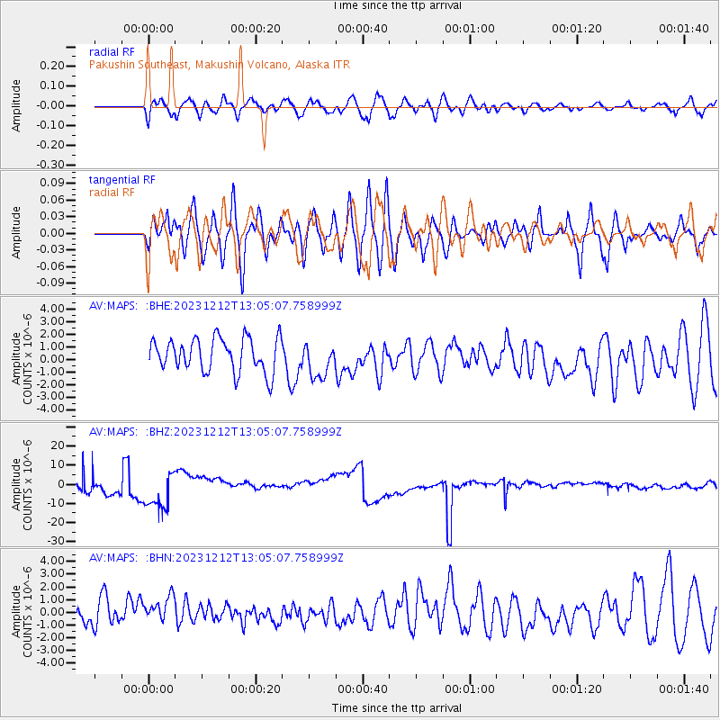
MAPS Pakushin Southeast, Makushin Volcano, Alaska - Earthquake Result Viewer
*The percent match for this event was below the threshold and hence no stack was calculated.
| Earthquake location: |
Tonga Islands |
| Earthquake latitude/longitude: |
-20.0/-173.4 |
| Earthquake time(UTC): |
2023/12/12 (346) 12:54:05 GMT |
| Earthquake Depth: |
10 km |
| Earthquake Magnitude: |
5.6 mww |
| Earthquake Catalog/Contributor: |
NEIC PDE/us |
|
| Network: |
AV Alaska Volcano Observatory |
| Station: |
MAPS Pakushin Southeast, Makushin Volcano, Alaska |
| Lat/Lon: |
53.81 N/166.94 W |
| Elevation: |
333 m |
|
| Distance: |
73.7 deg |
| Az: |
3.984 deg |
| Baz: |
186.326 deg |
| Ray Param: |
$rayparam |
*The percent match for this event was below the threshold and hence was not used in the summary stack. |
|
| Radial Match: |
57.046394 % |
| Radial Bump: |
400 |
| Transverse Match: |
50.685143 % |
| Transverse Bump: |
400 |
| SOD ConfigId: |
33437571 |
| Insert Time: |
2023-12-26 14:11:51.749 +0000 |
| GWidth: |
2.5 |
| Max Bumps: |
400 |
| Tol: |
0.001 |
|
Signal To Noise
| Channel | StoN | STA | LTA |
| AV:MAPS: :BHZ:20231212T13:05:07.758999Z | 2.5055518 | 8.629847E-6 | 3.4442899E-6 |
| AV:MAPS: :BHN:20231212T13:05:07.758999Z | 0.7678507 | 1.223966E-6 | 1.5940155E-6 |
| AV:MAPS: :BHE:20231212T13:05:07.758999Z | 1.0761609 | 1.4312221E-6 | 1.3299332E-6 |
| Arrivals |
| Ps | |
| PpPs | |
| PsPs/PpSs | |


