You are here: Home > Network List > IW - Intermountain West Stations List
> Station MOOW Moose Ponds, Wyoming, USA > Earthquake Result Viewer
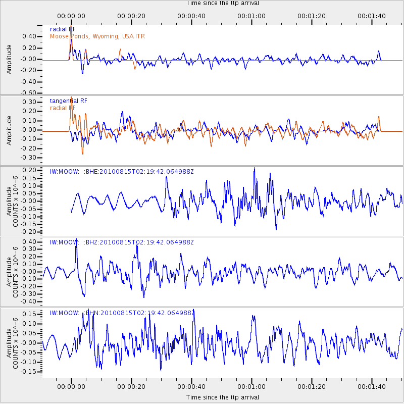
MOOW Moose Ponds, Wyoming, USA - Earthquake Result Viewer
*The percent match for this event was below the threshold and hence no stack was calculated.
| Earthquake location: |
Near East Coast Of Kamchatka |
| Earthquake latitude/longitude: |
53.6/160.1 |
| Earthquake time(UTC): |
2010/08/15 (227) 02:10:38 GMT |
| Earthquake Depth: |
40 km |
| Earthquake Magnitude: |
5.5 MB, 4.9 MS, 5.5 MW, 5.4 MW |
| Earthquake Catalog/Contributor: |
WHDF/NEIC |
|
| Network: |
IW Intermountain West |
| Station: |
MOOW Moose Ponds, Wyoming, USA |
| Lat/Lon: |
43.75 N/110.74 W |
| Elevation: |
2128 m |
|
| Distance: |
56.0 deg |
| Az: |
60.961 deg |
| Baz: |
313.966 deg |
| Ray Param: |
$rayparam |
*The percent match for this event was below the threshold and hence was not used in the summary stack. |
|
| Radial Match: |
71.71392 % |
| Radial Bump: |
400 |
| Transverse Match: |
76.251686 % |
| Transverse Bump: |
400 |
| SOD ConfigId: |
319893 |
| Insert Time: |
2011-01-05 23:20:27.340 +0000 |
| GWidth: |
2.5 |
| Max Bumps: |
400 |
| Tol: |
0.001 |
|
Signal To Noise
| Channel | StoN | STA | LTA |
| IW:MOOW: :BHZ:20100815T02:19:42.064988Z | 3.6308303 | 1.8158516E-7 | 5.0012023E-8 |
| IW:MOOW: :BHN:20100815T02:19:42.064988Z | 1.783246 | 6.4608855E-8 | 3.623104E-8 |
| IW:MOOW: :BHE:20100815T02:19:42.064988Z | 2.054927 | 6.73606E-8 | 3.2780047E-8 |
| Arrivals |
| Ps | |
| PpPs | |
| PsPs/PpSs | |


