You are here: Home > Network List > CI - Caltech Regional Seismic Network Stations List
> Station LRL Laurel Mtn Radio Fac, Ridgecrest, CA, USA > Earthquake Result Viewer
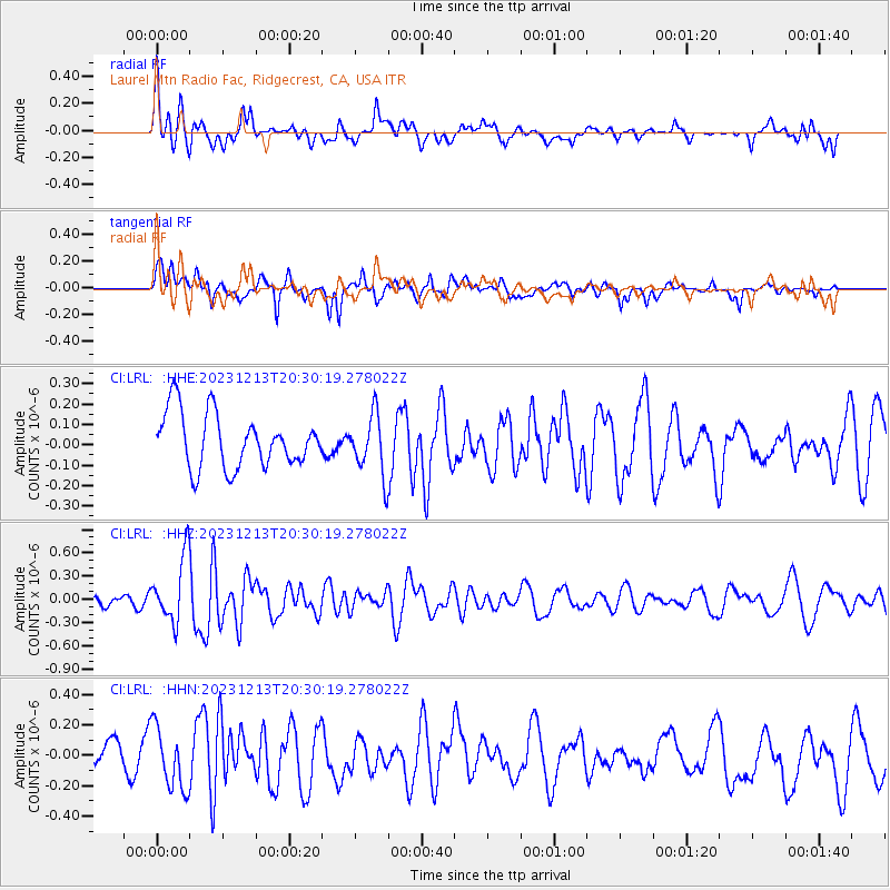
LRL Laurel Mtn Radio Fac, Ridgecrest, CA, USA - Earthquake Result Viewer
*The percent match for this event was below the threshold and hence no stack was calculated.
| Earthquake location: |
Norwegian Sea |
| Earthquake latitude/longitude: |
72.6/3.5 |
| Earthquake time(UTC): |
2023/12/13 (347) 20:20:10 GMT |
| Earthquake Depth: |
10 km |
| Earthquake Magnitude: |
5.5 mww |
| Earthquake Catalog/Contributor: |
NEIC PDE/us |
|
| Network: |
CI Caltech Regional Seismic Network |
| Station: |
LRL Laurel Mtn Radio Fac, Ridgecrest, CA, USA |
| Lat/Lon: |
35.48 N/117.68 W |
| Elevation: |
1340 m |
|
| Distance: |
64.9 deg |
| Az: |
309.558 deg |
| Baz: |
16.539 deg |
| Ray Param: |
$rayparam |
*The percent match for this event was below the threshold and hence was not used in the summary stack. |
|
| Radial Match: |
56.412567 % |
| Radial Bump: |
400 |
| Transverse Match: |
72.02219 % |
| Transverse Bump: |
400 |
| SOD ConfigId: |
33437571 |
| Insert Time: |
2023-12-27 20:31:37.063 +0000 |
| GWidth: |
2.5 |
| Max Bumps: |
400 |
| Tol: |
0.001 |
|
Signal To Noise
| Channel | StoN | STA | LTA |
| CI:LRL: :HHZ:20231213T20:30:19.278022Z | 6.149084 | 4.1738355E-7 | 6.787735E-8 |
| CI:LRL: :HHN:20231213T20:30:19.278022Z | 1.7995489 | 2.0027721E-7 | 1.1129301E-7 |
| CI:LRL: :HHE:20231213T20:30:19.278022Z | 1.1061764 | 1.4683611E-7 | 1.3274204E-7 |
| Arrivals |
| Ps | |
| PpPs | |
| PsPs/PpSs | |


