You are here: Home > Network List > US - United States National Seismic Network Stations List
> Station DGMT Dagmar, Montana, USA > Earthquake Result Viewer
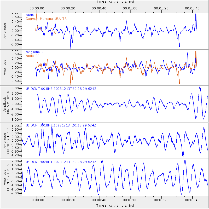
DGMT Dagmar, Montana, USA - Earthquake Result Viewer
*The percent match for this event was below the threshold and hence no stack was calculated.
| Earthquake location: |
Norwegian Sea |
| Earthquake latitude/longitude: |
72.6/3.5 |
| Earthquake time(UTC): |
2023/12/13 (347) 20:20:10 GMT |
| Earthquake Depth: |
10 km |
| Earthquake Magnitude: |
5.5 mww |
| Earthquake Catalog/Contributor: |
NEIC PDE/us |
|
| Network: |
US United States National Seismic Network |
| Station: |
DGMT Dagmar, Montana, USA |
| Lat/Lon: |
48.47 N/104.20 W |
| Elevation: |
646 m |
|
| Distance: |
49.4 deg |
| Az: |
303.372 deg |
| Baz: |
22.219 deg |
| Ray Param: |
$rayparam |
*The percent match for this event was below the threshold and hence was not used in the summary stack. |
|
| Radial Match: |
53.52441 % |
| Radial Bump: |
329 |
| Transverse Match: |
49.749344 % |
| Transverse Bump: |
376 |
| SOD ConfigId: |
33437571 |
| Insert Time: |
2023-12-27 20:52:14.042 +0000 |
| GWidth: |
2.5 |
| Max Bumps: |
400 |
| Tol: |
0.001 |
|
Signal To Noise
| Channel | StoN | STA | LTA |
| US:DGMT:00:BHZ:20231213T20:28:29.624Z | 2.115382 | 7.6221363E-7 | 3.6031963E-7 |
| US:DGMT:00:BH1:20231213T20:28:29.624Z | 0.9408822 | 7.7671376E-7 | 8.2551645E-7 |
| US:DGMT:00:BH2:20231213T20:28:29.624Z | 0.6495409 | 7.7706403E-7 | 1.1963281E-6 |
| Arrivals |
| Ps | |
| PpPs | |
| PsPs/PpSs | |


