You are here: Home > Network List > TA - USArray Transportable Network (new EarthScope stations) Stations List
> Station S26A Kim, CO, USA > Earthquake Result Viewer
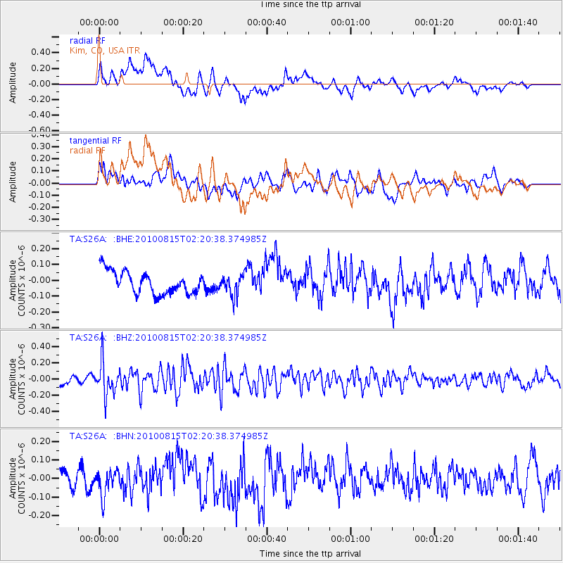
S26A Kim, CO, USA - Earthquake Result Viewer
*The percent match for this event was below the threshold and hence no stack was calculated.
| Earthquake location: |
Near East Coast Of Kamchatka |
| Earthquake latitude/longitude: |
53.6/160.1 |
| Earthquake time(UTC): |
2010/08/15 (227) 02:10:38 GMT |
| Earthquake Depth: |
40 km |
| Earthquake Magnitude: |
5.5 MB, 4.9 MS, 5.5 MW, 5.4 MW |
| Earthquake Catalog/Contributor: |
WHDF/NEIC |
|
| Network: |
TA USArray Transportable Network (new EarthScope stations) |
| Station: |
S26A Kim, CO, USA |
| Lat/Lon: |
37.62 N/103.47 W |
| Elevation: |
1394 m |
|
| Distance: |
64.2 deg |
| Az: |
61.201 deg |
| Baz: |
318.82 deg |
| Ray Param: |
$rayparam |
*The percent match for this event was below the threshold and hence was not used in the summary stack. |
|
| Radial Match: |
58.467186 % |
| Radial Bump: |
400 |
| Transverse Match: |
48.85672 % |
| Transverse Bump: |
400 |
| SOD ConfigId: |
319893 |
| Insert Time: |
2011-01-05 23:29:24.476 +0000 |
| GWidth: |
2.5 |
| Max Bumps: |
400 |
| Tol: |
0.001 |
|
Signal To Noise
| Channel | StoN | STA | LTA |
| TA:S26A: :BHZ:20100815T02:20:38.374985Z | 3.4056702 | 2.0471249E-7 | 6.0109315E-8 |
| TA:S26A: :BHN:20100815T02:20:38.374985Z | 1.4892725 | 7.0562116E-8 | 4.738026E-8 |
| TA:S26A: :BHE:20100815T02:20:38.374985Z | 0.9449487 | 6.71425E-8 | 7.105413E-8 |
| Arrivals |
| Ps | |
| PpPs | |
| PsPs/PpSs | |


