You are here: Home > Network List > IU - Global Seismograph Network (GSN - IRIS/USGS) Stations List
> Station RSSD Black Hills, South Dakota, USA > Earthquake Result Viewer
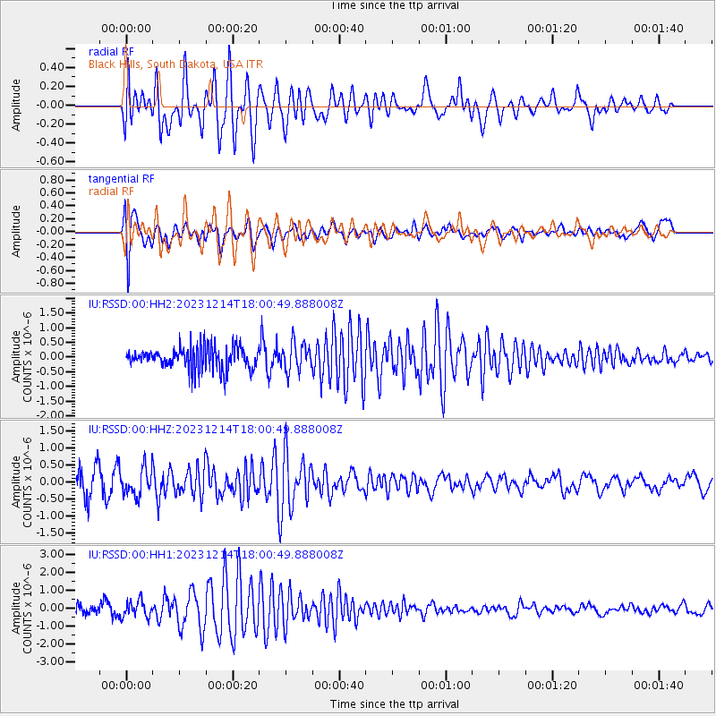
RSSD Black Hills, South Dakota, USA - Earthquake Result Viewer
*The percent match for this event was below the threshold and hence no stack was calculated.
| Earthquake location: |
Near Coast Of Guatemala |
| Earthquake latitude/longitude: |
14.0/-91.4 |
| Earthquake time(UTC): |
2023/12/14 (348) 17:55:01 GMT |
| Earthquake Depth: |
78 km |
| Earthquake Magnitude: |
5.4 Mww |
| Earthquake Catalog/Contributor: |
NEIC PDE/us |
|
| Network: |
IU Global Seismograph Network (GSN - IRIS/USGS) |
| Station: |
RSSD Black Hills, South Dakota, USA |
| Lat/Lon: |
44.12 N/104.04 W |
| Elevation: |
2090 m |
|
| Distance: |
31.9 deg |
| Az: |
342.667 deg |
| Baz: |
156.322 deg |
| Ray Param: |
$rayparam |
*The percent match for this event was below the threshold and hence was not used in the summary stack. |
|
| Radial Match: |
49.72095 % |
| Radial Bump: |
400 |
| Transverse Match: |
59.463566 % |
| Transverse Bump: |
400 |
| SOD ConfigId: |
33437571 |
| Insert Time: |
2023-12-28 18:10:24.983 +0000 |
| GWidth: |
2.5 |
| Max Bumps: |
400 |
| Tol: |
0.001 |
|
Signal To Noise
| Channel | StoN | STA | LTA |
| IU:RSSD:00:HHZ:20231214T18:00:49.888008Z | 1.251992 | 4.0123152E-7 | 3.2047453E-7 |
| IU:RSSD:00:HH1:20231214T18:00:49.888008Z | 1.5134473 | 4.6282875E-7 | 3.0581094E-7 |
| IU:RSSD:00:HH2:20231214T18:00:49.888008Z | 1.2815603 | 4.8538647E-7 | 3.787465E-7 |
| Arrivals |
| Ps | |
| PpPs | |
| PsPs/PpSs | |


